Sunrise Mountain Ridge Tucson, Arizona


View of Tucson


Sunrise Mountain Ridge - Severe Weather Alerts Details Page


Sunrise Mountain Ridge's Links:


Sunrise Mtn Current Page  ·  Sunrise Mtn Ridge History Page  ·  Sunrise Mtn Ridge Forecast/Summary Page


SUNRISE MTN RIDGE'S
7 DAY DETAIL FORECAST FOR TUCSON FOOTHILLS, AZ.

National Weather Service Forecast for: Catalina Foothills, AZ
Issued by: National Weather Service NWS Tucson Arizona
Updated: 11:33 am MST Jul 15, 2026

Sunrise Mtn Ridge Tucson Az
 
This
Afternoon
This Afternoon: Chance Showers And Thunderstorms
Chance Showers And T-Storms
Thursday

Thursday: Showers And Thunderstorms Likely
Showers And T-Storms Likely
Friday

Friday: Showers And Thunderstorms Likely
Showers And T-Storms Likely
Saturday

Saturday: Chance Showers And Thunderstorms
Chance Showers And T-Storms
Sunday

Sunday: Chance Showers And Thunderstorms
Chance Showers And T-Storms
Monday

Monday: Chance Showers And Thunderstorms
Chance Showers And T-Storms
Tuesday

Tuesday: Chance Showers And Thunderstorms
Chance Showers And T-Storms
 
Hi 98 °F Hi 94 °F Hi 91 °F Hi 92 °F Hi 94 °F Hi 94 °F Hi 96 °F  
 
Tonight

Tonight: Slight Chance Showers And Thunderstorms then Chance Showers And Thunderstorms
Slight Chance Showers And T-Storms then Chance Showers And T-Storms
Thursday
Night
Thursday Night: Chance Showers And Thunderstorms then Showers And Thunderstorms Likely
Chance Showers And T-Storms then Showers And T-Storms Likely
Friday
Night
Friday Night: Showers And Thunderstorms Likely
Showers And T-Storms Likely
Saturday
Night
Saturday Night: Slight Chance Showers And Thunderstorms then Chance Showers And Thunderstorms
Slight Chance Showers And T-Storms then Chance Showers And T-Storms
Sunday
Night
Sunday Night: Chance Showers And Thunderstorms
Chance Showers And T-Storms
Monday
Night
Monday Night: Chance Showers And Thunderstorms
Chance Showers And T-Storms
Tuesday
Night
Tuesday Night: Chance Showers And Thunderstorms
Chance Showers And T-Storms
 
Lo 76 °F Lo 72 °F Lo 72 °F Lo 73 °F Lo 74 °F Lo 74 °F Lo 74 °F  

Flood Watch


This Afternoon
 
A chance of showers and thunderstorms. Partly sunny, with a high near 98. Heat index values as high as 101. East northeast wind 0 to 3 mph. Chance of precipitation is 40%.
Tonight
 
A slight chance of showers and thunderstorms before 11pm, then a chance of showers and thunderstorms. Mostly cloudy, with a low around 76. East northeast wind around 3 mph. Chance of precipitation is 30%.
Thursday
 
A slight chance of rain showers before 8am, then showers and thunderstorms likely. Partly sunny. High near 94, with temperatures falling to around 88 in the afternoon. West southwest wind around 3 mph. Chance of precipitation is 70%.
Thursday Night
 
A chance of showers and thunderstorms before 11pm, then showers and thunderstorms likely. Mostly cloudy, with a low around 72. East southeast wind around 3 mph. Chance of precipitation is 60%.
Friday
 
Rain showers likely before 8am, then showers and thunderstorms likely between 8am and 2pm, then showers and thunderstorms likely between 2pm and 5pm, then showers and thunderstorms likely. Mostly cloudy, with a high near 91. South southwest wind around 3 mph. Chance of precipitation is 70%.
Friday Night
 
Showers and thunderstorms likely. Mostly cloudy, with a low around 72. Chance of precipitation is 60%.
Saturday
 
A chance of showers and thunderstorms before 11am, then a chance of showers and thunderstorms. Partly sunny, with a high near 92. Chance of precipitation is 50%.
Saturday Night
 
A slight chance of showers and thunderstorms before 11pm, then a chance of showers and thunderstorms. Mostly cloudy, with a low around 73. Chance of precipitation is 30%.
Sunday
 
A chance of rain showers before 11am, then a chance of showers and thunderstorms. Partly sunny, with a high near 94. Chance of precipitation is 30%.
Sunday Night
 
A chance of showers and thunderstorms before 11pm, then a chance of showers and thunderstorms. Mostly cloudy, with a low around 74. Chance of precipitation is 40%.
Monday
 
A chance of rain showers before 11am, then a chance of showers and thunderstorms. Partly sunny, with a high near 94. Chance of precipitation is 40%.
Monday Night
 
A chance of showers and thunderstorms before 11pm, then a chance of showers and thunderstorms. Mostly cloudy, with a low around 74. Chance of precipitation is 40%.
Tuesday
 
A chance of rain showers before 11am, then a chance of showers and thunderstorms. Partly sunny, with a high near 96. Chance of precipitation is 40%.
Tuesday Night
 
A chance of showers and thunderstorms. Partly cloudy, with a low around 74.


Forecast from NOAA-NWS for Catalina Foothills, AZ.


Tucson, Az - Area Forecast Discussion

Forecast Discussion for TWC NWS Office
582
FXUS65 KTWC 152200
AFDTWC

Area Forecast Discussion
National Weather Service Tucson AZ
300 PM MST Wed Jul 15 2026

.SYNOPSIS...Scattered thunderstorms this evening with heavy rain
and strong gusty winds possible near any thunderstorm. More
widespread chances for showers and thunderstorms are forecast on
Thursday and potentially Friday with an increased risk of flash
flooding. High temperatures will be below normal for the next 7
days.

&&

.DISCUSSION...A very active monsoon pattern will continue for
the foreseeable future. Rather chaotic upper air pattern via
water vapor imagery which shows an upper low over srn Baja, an
upper low over cntrl TX, large expansive upper ridge that
extends from ern CONUS west to the interior west with a high
centered near Salt Lake City. And in the tropics, there is TS
Elida, which was located 570 miles SSW off the srn tip of Baja
per the latest NHC advisory.

We have NE flow over the area today between the upper high near
Salt Lake City and the cntrl TX upper low. Ample moisture is in
place for scattered showers and thunderstorms as they propagate
NE-SW. Main threats will be strong gusty outflow winds, some of
which may briefly be severe, localized heavy rain and flash
flooding.

Thursday: Flash flooding concerns will be heightened thanks to
additional moisture advection into the area with PWATs ranging
from 1.25" far east to over 2" west of Tucson and sufficient
dynamics over the area. Thunderstorms developing over the
mountains will propagate to the SW under NE flow aloft. Outflow
interactions will continue to develop strong wet microbursts
from Tucson west late Thursday afternoon into Thursday night.
Localized rainfall rates up to 2"/hr are possible with some of
the very wet storms leading to flash flooding. From WPC,
HREF/REFS guidance had low end chances, (10-30%), of rainfall
totals exceeding 5", especially west of Tucson. With that said,
and in coordination with WPC, added a rare Moderate Risk (MDT,
at least 40%) in the Excessive Rainfall Outlook (ERO) for
excessive rainfall within 25 miles of a point, for SW Cochise
county, all of Santa Cruz county, ern Pima county (mainly S of
Tucson at this time) and central Pima county. A Flash Flood
watch was issued for most of the area Thursday afternoon into
early Friday morning. We may see some interesting average
recurrence intervals (ARI) on Thursday. Of note: the last time
SE AZ had an area MDT ERO was on Sept 21, 2022.

Friday has the potential to be another active day but confidence
is low due to what happens on Thursday. Could end up with an MCV
moving thru which will diminish chances.

Wet monsoon pattern continues this weekend into the first half
of next week with daily chance of showers and thunderstorms.

High temperatures will run below normal for the next 7 days.

&&

.AVIATION...Valid through 17/00Z.
Widely SCTD -SHRA/-TS thru 16/04z then SCTD -SHRA/TS aft 16/19z.
Ceilings mostly 9k-12k ft. Hvy rain, mtn OBSCN and erratic
strong wind gusts of 35-45 kts psbl with any TS. Outside of TS,
SFC winds generally under 10 kts. Aviation discussion not updated
for TAF amendments.

&&

.FIRE WEATHER...Daily chances for thunderstorms will continue
each afternoon and evening through the next 7 days with day to
day variability. More widespread chances for showers and
thunderstorms are likely Thursday and potentially Friday.
Minimum relative humidity 25-30 percent in the lower desert
locations and above 40 percent in the mountains this week. Winds
this week will remain mainly light and under 15 mph, though
strong and erratic winds will be possible with any thunderstorm.

&&

.HYDROLOGY...The heavy rains on Thursday may lead to some
significant rises in washes, creeks and rivers, especially from
western Cochise county west into central Pima county.

&&

.TWC WATCHES/WARNINGS/ADVISORIES...
 Flood Watch from Thursday afternoon through late Thursday
  night for AZZ502>506-514-515.
 Flood Watch from Thursday afternoon through Thursday evening
  for AZZ507>509-511>513.

&&

$$

Visit us on Facebook, X, YouTube, and at weather.gov/Tucson

NWS TWC Office Area Forecast Discussion


Local & Regional Weather Statements, Watches And Warnings

Weather Alerts for Pinal County

Issued by the National Weather Service

Flash Flood Warning  FLASH FLOOD WARNING   Flash Flood Warning
PINAL COUNTY

Areas Affected:
Pinal, AZ
Effective: Wed, 7/15 5:40pm Updated: Wed, 7/15 5:51pm Urgency: Immediate
Expires: Wed, 7/15 8:45pm Severity:  Severe  Certainty: Likely

 
Details:
FFWTWC

The National Weather Service in Tucson has issued a

* Flash Flood Warning for...
South Central Pinal County in southeastern Arizona...

* Until 845 PM MST.

* At 540 PM MST, Doppler radar indicated thunderstorms producing
heavy rain across the warned area. Between 1 and 1.5 inches of rain
have fallen. Additional rainfall amounts up to 1 inch are possible
in the warned area. Flash flooding is ongoing or expected to begin
shortly.

HAZARD...Flash flooding caused by thunderstorms.

SOURCE...Radar indicated.

IMPACT...Flash flooding of small creeks and streams, urban areas,
highways, streets and underpasses as well as other poor
drainage and low-lying areas.

* Some locations that will experience flash flooding include...
Mainly rural areas of South Central Pinal County.

This includes Route 79 between mile markers 95 and 104.

This includes the following Flash Flood Prone Locations...
Suizo Rd at Cadillac Wash.

Information:
Turn around, don't drown when encountering flooded roads. Most flood
deaths occur in vehicles.

In hilly terrain there are hundreds of low water crossings which are
potentially dangerous in heavy rain. Do not attempt to cross flooded
roads. Find an alternate route.

Flash Flood Warning  FLASH FLOOD WARNING   Flash Flood Warning
PINAL COUNTY

Areas Affected:
Pinal, AZ
Effective: Wed, 7/15 4:49pm Updated: Wed, 7/15 5:51pm Urgency: Immediate
Expires: Wed, 7/15 7:45pm Severity:  Severe  Certainty: Likely

 
Details:
FFWTWC

The National Weather Service in Tucson has issued a

* Flash Flood Warning for...
Southeastern Pinal County in southeastern Arizona...

* Until 745 PM MST.

* At 449 PM MST, Doppler radar indicated thunderstorms producing
heavy rain across the warned area. Between 0.5 and 1.5 inches of
rain have fallen. Additional rainfall amounts up to 1 inch are
possible in the warned area. Flash flooding is ongoing or expected
to begin shortly.

HAZARD...Flash flooding caused by thunderstorms.

SOURCE...Radar indicated.

IMPACT...Flash flooding of small creeks and streams, urban areas,
highways, streets and underpasses as well as other poor
drainage and low-lying areas.

* Some locations that will experience flash flooding include...
Oracle, Saddlebrooke, Saddlebrooke Ranch and Biosphere 2.

This includes Route 77 between mile markers 94 and 109.

Information:
Turn around, don't drown when encountering flooded roads. Most flood
deaths occur in vehicles.

In hilly terrain there are hundreds of low water crossings which are
potentially dangerous in heavy rain. Do not attempt to cross flooded
roads. Find an alternate route.

Dust Advisory  DUST ADVISORY   Dust Advisory
PINAL COUNTY

Areas Affected:
Pima, AZ - Pinal, AZ
Effective: Wed, 7/15 5:48pm Updated: Wed, 7/15 5:51pm Urgency: Expected
Expires: Wed, 7/15 7:45pm Severity:  Moderate  Certainty: Likely

 
Details:
The National Weather Service in Tucson has issued a

* Dust Advisory for...
North Central Pima County in southeastern Arizona...
South Central Pinal County in southeastern Arizona...

* Until 745 PM MST.

* At 548 PM MST, an area of blowing dust was located near Pinal
Airpark, moving southwest at 10 mph toward Interstate 10.

HAZARD...Less than three miles visibility.

SOURCE...Trained spotters reported dust south of Picacho Peak and
in Red Rock at or approaching Interstate 10.

IMPACT...Hazardous travel.

* Locations impacted include...
Marana, Avra Valley, Picacho, Pinal Airpark, Picacho Peak State
Park, Picture Rocks, Red Rock and Dove Mountain.

This includes the following highways...
Route 87 near mile marker 116. Interstate 10 between mile markers 210
and 241.

Information:
Motorists should not drive into an area of blowing dust. PULL ASIDE
STAY ALIVE!

Flood Watch  FLOOD WATCH   Flood Watch
PINAL COUNTY

Areas Affected:
Tohono O'odham Nation including Sells - Upper Santa Cruz River and Altar Valleys including Nogales - Tucson Metro Area including Tucson/Green Valley/Marana/Vail - South Central Pinal County including Eloy/Picacho Peak State Park - Southeast Pinal County including Kearny/Mammoth/Oracle - Santa Catalina and Rincon Mountains including Mount Lemmon/Summerhaven - Baboquivari Mountains including Kitt Peak
Effective: Wed, 7/15 10:44am Updated: Wed, 7/15 5:51pm Urgency: Future
Expires: Thu, 7/16 5:00am Severity:  Severe  Certainty: Possible

 
Details:
* WHAT...Scattered showers and thunderstorms will be capable of
producing very heavy rain in a short period of time. The excessive
rain will lead to increased chances for flash flooding. The heavy
rain will also lead to significant flow in area washes, creeks, and
rivers.

* WHERE...A portion of Southeast Arizona, including the following
areas, Baboquivari Mountains, Catalina and Rincon Mountains, South
Central Pinal County, Southeast Pinal County, Tohono O'odham
Nation, Tucson Metro Area and Upper Santa Cruz River Valley/Altar
Valley.

* WHEN...From Thursday afternoon through late Thursday night.

* IMPACTS...Excessive runoff may result in flooding of rivers,
creeks, streams, and other low-lying and flood-prone locations.

* ADDITIONAL DETAILS...
- Daytime heating will combine with a very moist atmosphere to
produced scattered showers and thunderstorms which will be
capable of producing very heavy rain. Storms will continue after
sunset. Isolated rainfall totals of 1 to 3 inches are possible.
- http://www.weather.gov/safety/flood

Information:
You should monitor later forecasts and be alert for possible Flood
Warnings. Those living in areas prone to flooding should be prepared
to take action should flooding develop.

Flood Watch  FLOOD WATCH   Flood Watch
PINAL COUNTY

Areas Affected:
Upper San Pedro River Valley including Sierra Vista/Benson - Eastern Cochise County Below 5000 Feet including Douglas/Willcox - Upper Gila River and Aravaipa Valleys including Clifton/Safford - Galiuro and Pinaleno Mountains including Mount Graham - Chiricahua Mountains including Chiricahua National Monument - Dragoon/Mule/Huachuca and Santa Rita Mountains including Bisbee/Canelo Hills/Madera Canyon
Effective: Wed, 7/15 10:44am Updated: Wed, 7/15 5:51pm Urgency: Future
Expires: Thu, 7/16 5:00am Severity:  Severe  Certainty: Possible

 
Details:
* WHAT...Scattered showers and thunderstorms will be capable of
producing very heavy rain in a short period of time. The excessive
rain will lead to increased chances for flash flooding. The heavy
rain will also lead to significant flow in area washes, creeks, and
rivers.

* WHERE...A portion of Southeast Arizona, including the following
areas, Chiricahua Mountains, Dragoon and Mule and Huachuca and
Santa Rita Mountains, Eastern Cochise County below 5000 feet,
Galiuro and Pinaleno Mountains, Upper Gila River Valley and Upper
San Pedro River Valley.

* WHEN...From Thursday afternoon through Thursday evening.

* IMPACTS...Excessive runoff may result in flooding of rivers,
creeks, streams, and other low-lying and flood-prone locations.

* ADDITIONAL DETAILS...
- Daytime heating will combine with a very moist atmosphere to
produced scattered showers and thunderstorms which will be
capable of producing very heavy rain. Isolated rainfall totals of
1 to 3 inches are possible.
- http://www.weather.gov/safety/flood

Information:
You should monitor later forecasts and be alert for possible Flood
Warnings. Those living in areas prone to flooding should be prepared
to take action should flooding develop.

Flood Watch  FLOOD WATCH   Flood Watch
PINAL COUNTY

Areas Affected:
Aguila Valley - Northwest Valley - Tonopah Desert - Gila Bend - Buckeye/Avondale - Cave Creek/New River - Deer Valley - Central Phoenix - North Phoenix/Glendale - New River Mesa - Scottsdale/Paradise Valley - Rio Verde/Salt River - East Valley - Fountain Hills/East Mesa - South Mountain/Ahwatukee - Southeast Valley/Queen Creek - Superior - Northwest Pinal County - West Pinal County - Apache Junction/Gold Canyon - Tonto Basin - Mazatzal Mountains - Pinal/Superstition Mountains - Sonoran Desert Natl Monument - San Carlos - Dripping Springs - Globe/Miami - Southeast Gila County
Effective: Wed, 7/15 1:02pm Updated: Wed, 7/15 5:51pm Urgency: Future
Expires: Thu, 7/16 4:30am Severity:  Severe  Certainty: Possible

 
Details:
* WHAT...Flooding caused by excessive rainfall is possible.

* WHERE...South-central Arizona, including the following areas,
southern Gila County including the city of Globe, Maricopa County
including the Phoenix metropolitan area, and northern Pinal County.

* WHEN...From Thursday afternoon through late Thursday night.

* IMPACTS...Excessive runoff may result in flooding of rivers,
creeks, streams, and other low-lying and flood-prone locations.
Flooding may occur in poor drainage and urban areas. Low-water
crossings may be flooded.

* ADDITIONAL DETAILS...
- Slow moving thunderstorms and those moving over the same areas
feeding off a high moisture environment may result in rainfall
rates in excess of 2-3"/hr.
- http://www.weather.gov/safety/flood

Information:
You should monitor later forecasts and be alert for possible Flood
Warnings. Those living in areas prone to flooding should be prepared
to take action should flooding develop.

Special Weather Statement  SPECIAL WEATHER STATEMENT   Special Weather Statement
PINAL COUNTY

Areas Affected:
New River Mesa - Rio Verde/Salt River - Superior - Tonto Basin - Mazatzal Mountains - Pinal/Superstition Mountains - San Carlos - Dripping Springs - Globe/Miami - Southeast Gila County
Effective: Wed, 7/15 4:35pm Updated: Wed, 7/15 5:51pm Urgency: Expected
Expires: Wed, 7/15 6:30pm Severity:  Moderate  Certainty: Observed

 
Details:
At 434 PM MST, radar indicated strong thunderstorms were located
along a line extending from near Sunflower to 9 miles south of Coon
Creek CG to near San Carlos. Movement was west at 10 mph.

Conditions are becoming more favorable for the development of
additional thunderstorms. Some storms may become strong to severe.

Winds in excess of 40 mph will be possible.

Locations impacted include...
Globe, Superior, Hayden, Christmas, Sycamore Creek, Ballantine
Trailhead, Roosevelt, Round Valley, Sunflower, San Carlos, Miami,
Cutter, Hilltop, Roosevelt Dam, Top-Of-The-World, Sawmill, Central
Heights-Midland City, Tonto National Monument, Four Peaks, and Apache
Lake.

This includes the following highways...
US Highway 60 between mile markers 227 and 285.
AZ Route 87 between mile markers 209 and 229.
AZ Route 70 between mile markers 253 and 271.

Torrential rainfall is also occurring with these storms, and may
cause localized flooding. Do not drive your vehicle through flooded
roadways.

Frequent cloud to ground lightning is occurring with this storm.
Lightning can strike 10 miles away from a thunderstorm. Seek a safe
shelter inside a building or vehicle.

Air Quality Alert  AIR QUALITY ALERT   Air Quality Alert
PINAL COUNTY

Areas Affected:
Pinal, AZ
Effective: Wed, 7/15 10:12am Updated: Wed, 7/15 5:51pm Urgency: Unknown
Expires: Wed, 7/15 9:00pm Severity: Unknown Certainty: Unknown

 
Details:
AQAPSR

The Arizona Department of Environmental Quality (ADEQ) has issued an
Ozone and PM-10 High Pollution Advisory for Pinal County Wednesday.

This means that forecast weather conditions combined with existing
ozone levels are expected to result in local maximum 8-hour ozone
concentrations that pose a health risk. Adverse health effects
increase as air quality deteriorates.

Ozone is an air contaminant which can cause breathing difficulties
for children, older adults, as well as persons with respiratory
problems. A decrease in physical activity is recommended.

You are urged to car pool, telecommute or use mass transit.
The use of gasoline-powered equipment should be reduced or done late
in the day.

Also, an episode of strong and gusty winds is forecast to generate
widespread blowing dust that may result in local PM-10 concentrations
that pose a health risk. Adverse health effects increase as air
quality deteriorates.

Coarse particulate matter - also known as PM-10 - is an air
contaminant that can aggravate heart and lung disease conditions,
especially in older adults, children, and those with asthma. A
decrease in physical activity is recommended.

Consolidate your travel, stabilize loose soils, slow down or avoid
travel on dirt roads, reduce or eliminate fireplace use, and avoid
using gas-powered lawn equipment.

For details on this High Pollution Advisory, visit the ADEQ internet
site at www.azdeq.gov/forecast/WestPinal or call 602-771-2300.


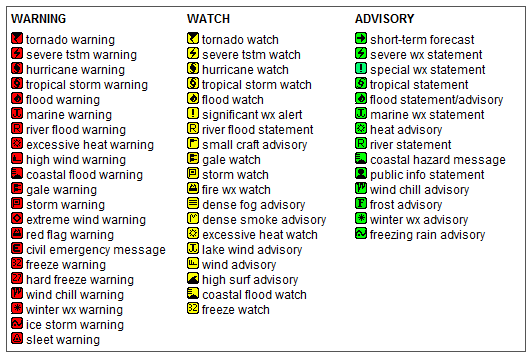
Key to Icons for Local & Regional Weather Statements, Watches And Warnings

Alerts Key

Map of the Current Watches, Warnings, and Advisories Nationwide:
national advisories


Pepper Ridge Weather Station


Page Last Updated May 5th, 2024

Tucson Historical Data Archieves


Copyright © 2006 - 2024, Sunrise Mountain Ridge Weather - All rights reserved .
Unauthorized duplication or distribution is prohibited
Powered By: | WeatherLink 5.71 |
Site Template Designed by: Pali Plumies Designs

Disclaimer:
Never base important decisions on this or any weather information obtained from the Internet.

Number of Visitors Since March 15, 2005


USA Weather Finder Return to Main Forecast Page World Weather Websites

United States Weather Group

LightningRing