Sunrise Mountain Ridge Tucson, Arizona


View of Tucson


Sunrise Mountain Ridge - Severe Weather Alerts Details Page


Sunrise Mountain Ridge's Links:


Sunrise Mtn Current Page  ·  Sunrise Mtn Ridge History Page  ·  Sunrise Mtn Ridge Forecast/Summary Page


SUNRISE MTN RIDGE'S
7 DAY DETAIL FORECAST FOR TUCSON FOOTHILLS, AZ.

National Weather Service Forecast for: Catalina Foothills, AZ
Issued by: National Weather Service NWS Tucson Arizona
Updated: 11:33 am MST Jul 15, 2026

Sunrise Mtn Ridge Tucson Az
 
This
Afternoon
This Afternoon: Chance Showers And Thunderstorms
Chance Showers And T-Storms
Thursday

Thursday: Showers And Thunderstorms Likely
Showers And T-Storms Likely
Friday

Friday: Showers And Thunderstorms Likely
Showers And T-Storms Likely
Saturday

Saturday: Chance Showers And Thunderstorms
Chance Showers And T-Storms
Sunday

Sunday: Chance Showers And Thunderstorms
Chance Showers And T-Storms
Monday

Monday: Chance Showers And Thunderstorms
Chance Showers And T-Storms
Tuesday

Tuesday: Chance Showers And Thunderstorms
Chance Showers And T-Storms
 
Hi 98 °F Hi 94 °F Hi 91 °F Hi 92 °F Hi 94 °F Hi 94 °F Hi 96 °F  
 
Tonight

Tonight: Slight Chance Showers And Thunderstorms then Chance Showers And Thunderstorms
Slight Chance Showers And T-Storms then Chance Showers And T-Storms
Thursday
Night
Thursday Night: Chance Showers And Thunderstorms then Showers And Thunderstorms Likely
Chance Showers And T-Storms then Showers And T-Storms Likely
Friday
Night
Friday Night: Showers And Thunderstorms Likely
Showers And T-Storms Likely
Saturday
Night
Saturday Night: Slight Chance Showers And Thunderstorms then Chance Showers And Thunderstorms
Slight Chance Showers And T-Storms then Chance Showers And T-Storms
Sunday
Night
Sunday Night: Chance Showers And Thunderstorms
Chance Showers And T-Storms
Monday
Night
Monday Night: Chance Showers And Thunderstorms
Chance Showers And T-Storms
Tuesday
Night
Tuesday Night: Chance Showers And Thunderstorms
Chance Showers And T-Storms
 
Lo 76 °F Lo 72 °F Lo 72 °F Lo 73 °F Lo 74 °F Lo 74 °F Lo 74 °F  

Flood Watch


This Afternoon
 
A chance of showers and thunderstorms. Partly sunny, with a high near 98. Heat index values as high as 101. East northeast wind 0 to 3 mph. Chance of precipitation is 40%.
Tonight
 
A slight chance of showers and thunderstorms before 11pm, then a chance of showers and thunderstorms. Mostly cloudy, with a low around 76. East northeast wind around 3 mph. Chance of precipitation is 30%.
Thursday
 
A slight chance of rain showers before 8am, then showers and thunderstorms likely. Partly sunny. High near 94, with temperatures falling to around 88 in the afternoon. West southwest wind around 3 mph. Chance of precipitation is 70%.
Thursday Night
 
A chance of showers and thunderstorms before 11pm, then showers and thunderstorms likely. Mostly cloudy, with a low around 72. East southeast wind around 3 mph. Chance of precipitation is 60%.
Friday
 
Rain showers likely before 8am, then showers and thunderstorms likely between 8am and 2pm, then showers and thunderstorms likely between 2pm and 5pm, then showers and thunderstorms likely. Mostly cloudy, with a high near 91. South southwest wind around 3 mph. Chance of precipitation is 70%.
Friday Night
 
Showers and thunderstorms likely. Mostly cloudy, with a low around 72. Chance of precipitation is 60%.
Saturday
 
A chance of showers and thunderstorms before 11am, then a chance of showers and thunderstorms. Partly sunny, with a high near 92. Chance of precipitation is 50%.
Saturday Night
 
A slight chance of showers and thunderstorms before 11pm, then a chance of showers and thunderstorms. Mostly cloudy, with a low around 73. Chance of precipitation is 30%.
Sunday
 
A chance of rain showers before 11am, then a chance of showers and thunderstorms. Partly sunny, with a high near 94. Chance of precipitation is 30%.
Sunday Night
 
A chance of showers and thunderstorms before 11pm, then a chance of showers and thunderstorms. Mostly cloudy, with a low around 74. Chance of precipitation is 40%.
Monday
 
A chance of rain showers before 11am, then a chance of showers and thunderstorms. Partly sunny, with a high near 94. Chance of precipitation is 40%.
Monday Night
 
A chance of showers and thunderstorms before 11pm, then a chance of showers and thunderstorms. Mostly cloudy, with a low around 74. Chance of precipitation is 40%.
Tuesday
 
A chance of rain showers before 11am, then a chance of showers and thunderstorms. Partly sunny, with a high near 96. Chance of precipitation is 40%.
Tuesday Night
 
A chance of showers and thunderstorms. Partly cloudy, with a low around 74.


Forecast from NOAA-NWS for Catalina Foothills, AZ.


Tucson, Az - Area Forecast Discussion

Forecast Discussion for TWC NWS Office
582
FXUS65 KTWC 152200
AFDTWC

Area Forecast Discussion
National Weather Service Tucson AZ
300 PM MST Wed Jul 15 2026

.SYNOPSIS...Scattered thunderstorms this evening with heavy rain
and strong gusty winds possible near any thunderstorm. More
widespread chances for showers and thunderstorms are forecast on
Thursday and potentially Friday with an increased risk of flash
flooding. High temperatures will be below normal for the next 7
days.

&&

.DISCUSSION...A very active monsoon pattern will continue for
the foreseeable future. Rather chaotic upper air pattern via
water vapor imagery which shows an upper low over srn Baja, an
upper low over cntrl TX, large expansive upper ridge that
extends from ern CONUS west to the interior west with a high
centered near Salt Lake City. And in the tropics, there is TS
Elida, which was located 570 miles SSW off the srn tip of Baja
per the latest NHC advisory.

We have NE flow over the area today between the upper high near
Salt Lake City and the cntrl TX upper low. Ample moisture is in
place for scattered showers and thunderstorms as they propagate
NE-SW. Main threats will be strong gusty outflow winds, some of
which may briefly be severe, localized heavy rain and flash
flooding.

Thursday: Flash flooding concerns will be heightened thanks to
additional moisture advection into the area with PWATs ranging
from 1.25" far east to over 2" west of Tucson and sufficient
dynamics over the area. Thunderstorms developing over the
mountains will propagate to the SW under NE flow aloft. Outflow
interactions will continue to develop strong wet microbursts
from Tucson west late Thursday afternoon into Thursday night.
Localized rainfall rates up to 2"/hr are possible with some of
the very wet storms leading to flash flooding. From WPC,
HREF/REFS guidance had low end chances, (10-30%), of rainfall
totals exceeding 5", especially west of Tucson. With that said,
and in coordination with WPC, added a rare Moderate Risk (MDT,
at least 40%) in the Excessive Rainfall Outlook (ERO) for
excessive rainfall within 25 miles of a point, for SW Cochise
county, all of Santa Cruz county, ern Pima county (mainly S of
Tucson at this time) and central Pima county. A Flash Flood
watch was issued for most of the area Thursday afternoon into
early Friday morning. We may see some interesting average
recurrence intervals (ARI) on Thursday. Of note: the last time
SE AZ had an area MDT ERO was on Sept 21, 2022.

Friday has the potential to be another active day but confidence
is low due to what happens on Thursday. Could end up with an MCV
moving thru which will diminish chances.

Wet monsoon pattern continues this weekend into the first half
of next week with daily chance of showers and thunderstorms.

High temperatures will run below normal for the next 7 days.

&&

.AVIATION...Valid through 17/00Z.
Widely SCTD -SHRA/-TS thru 16/04z then SCTD -SHRA/TS aft 16/19z.
Ceilings mostly 9k-12k ft. Hvy rain, mtn OBSCN and erratic
strong wind gusts of 35-45 kts psbl with any TS. Outside of TS,
SFC winds generally under 10 kts. Aviation discussion not updated
for TAF amendments.

&&

.FIRE WEATHER...Daily chances for thunderstorms will continue
each afternoon and evening through the next 7 days with day to
day variability. More widespread chances for showers and
thunderstorms are likely Thursday and potentially Friday.
Minimum relative humidity 25-30 percent in the lower desert
locations and above 40 percent in the mountains this week. Winds
this week will remain mainly light and under 15 mph, though
strong and erratic winds will be possible with any thunderstorm.

&&

.HYDROLOGY...The heavy rains on Thursday may lead to some
significant rises in washes, creeks and rivers, especially from
western Cochise county west into central Pima county.

&&

.TWC WATCHES/WARNINGS/ADVISORIES...
 Flood Watch from Thursday afternoon through late Thursday
  night for AZZ502>506-514-515.
 Flood Watch from Thursday afternoon through Thursday evening
  for AZZ507>509-511>513.

&&

$$

Visit us on Facebook, X, YouTube, and at weather.gov/Tucson
NWS TWC Office Area Forecast Discussion


Local & Regional Weather Statements, Watches And Warnings

Weather Alerts for Yavapai County

Issued by the National Weather Service

Flood Advisory  FLOOD ADVISORY   Flood Advisory
YAVAPAI COUNTY

Areas Affected:
Yavapai, AZ
Effective: Wed, 7/15 4:55pm Updated: Wed, 7/15 5:51pm Urgency: Expected
Expires: Wed, 7/15 6:30pm Severity: Minor Certainty: Likely

 
Details:
* WHAT...Flooding caused by excessive rainfall continues.

* WHERE...Chino Valley and Paulden in Yavapai County in west central
Arizona...

* WHEN...Until 630 PM MST.

* IMPACTS...Minor flooding in creeks and normally dry washes is
imminent or occurring. Water flowing over roadways will create
slick roads and muddy unpaved roads. Some low-water crossings may
become impassable. Ponding of water on highways and in urban areas
will create hazardous travel conditions.

* ADDITIONAL DETAILS...
- At 453 PM MST, Doppler radar indicated that the heavy rainfall
had ended across the advisory area, however, minor flooding
remains a threat from earlier heavy rainfall. Minor flooding is
ongoing or expected to begin shortly in the advisory area.
Between 1 and 2 inches of rain have fallen.
- This includes the following creeks, washes and rivers...
Mint Wash, Antelope Wash, Strickland Wash, Wagon Tire Wash, Verde
River, Little Chino Valley, Walnut Creek, Williamson Valley Wash,
Cooper Wash, Big Chino Wash, Hell Canyon, Butte Wash, Dillon
Wash, Mud Tank Wash and Granite Creek. Additional rainfall
amounts up to 0.25 inches are expected over the area.
- Some locations that will experience flooding include...
Chino Valley, Williamson Valley, Paulden, Drake and Granite
Mountain Wilderness.
- This includes State Route 89 between mile markers 325 and 346.
- Additional information is available at weather.gov/flagstaff.

Information:
Be aware of your surroundings and do not drive on flooded roads.

Low water crossings will become dangerous in heavy rain. Do not
attempt to cross flooded roads. Find an alternate route.

Flood Watch  FLOOD WATCH   Flood Watch
YAVAPAI COUNTY

Areas Affected:
Yavapai County Mountains - Northern Gila County - Yavapai County Valleys and Basins - Oak Creek and Sycamore Canyons
Effective: Wed, 7/15 1:30pm Updated: Wed, 7/15 5:51pm Urgency: Future
Expires: Wed, 7/15 11:00pm Severity:  Severe  Certainty: Possible

 
Details:
* WHAT...Flash flooding caused by excessive rainfall continues to be
possible.

* WHERE...Portions of east central and west central Arizona,
including the following areas, in east central Arizona, Northern
Gila County. In west central Arizona, Oak Creek and Sycamore
Canyons, Yavapai County Mountains and Yavapai County Valleys and
Basins.

* WHEN...Until 11 PM MST this evening.

* IMPACTS...Flash flooding will be possible in creeks, normally dry
washes, swimming holes, and over recently burned areas. Low-water
crossings may be flooded.

* ADDITIONAL DETAILS...
- Abundant monsoon moisture is in place. Thunderstorms developing
over the higher terrain will move into the watch area during the
afternoon and evening. Some storms will be capable of producing
1-2" of rain in less than one hour.
- Additional information is available at weather.gov/flagstaff.

Information:
Have a way to receive Flash Flood Warnings and be prepared to take
action should warnings be issued.


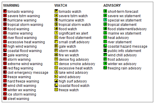
Key to Icons for Local & Regional Weather Statements, Watches And Warnings

Alerts Key

Map of the Current Watches, Warnings, and Advisories Nationwide:

national advisories


Pepper Ridge Weather Station


Page Last Updated May 5th, 2024

Tucson Historical Data Archieves


Copyright © 2006 - 2024, Sunrise Mountain Ridge Weather - All rights reserved .
Unauthorized duplication or distribution is prohibited
Powered By: | WeatherLink 5.71 |
Site Template Designed by: Pali Plumies Designs

Disclaimer:
Never base important decisions on this or any weather information obtained from the Internet.

Number of Visitors Since March 15, 2005


USA Weather Finder Return to Main Forecast Page World Weather Websites

United States Weather Group

LightningRing