Gulf
of California Surges
What is A Gulf of California Moisture Surge?
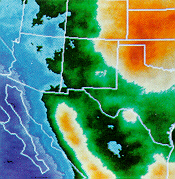
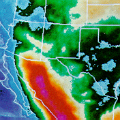
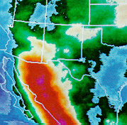
A Gulf of California moisture surge is a low-level
flow of moist, relatively cool air that moves northward over
the Gulf of California and into Arizona. Surges of moisture
from the Gulf of California provide the fuel that feeds the
wide spread and intense storms that form over the low desert
of Arizona.
What conditions set-up a Gulf surge?
A Gulf Surge can occur whenever the surface
based thermal low over the southwest United States is intensifying
at the same time large thunderstorm complexes are forming
over northwest Mexico. Many of the severe and heavy rain producing
thunderstorms that form over the low desert of Arizona during
the monsoon are directly related to Gulf of California moisture
surges.
The most common large-scale pattern observed
before a Gulf Surge is an easterly wave passing over central
portions of Mexico at the same time mid-level high pressure
and very hot weather are plaguing Arizona. Hot weather normally
intensifies the surface based thermal low over the southwest
United States.

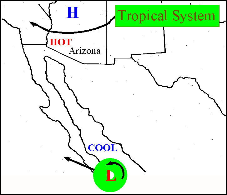
A less frequently observed pattern for a Gulf
Surge is when a tropical storm or hurricane is located near
the southern tip of Baja California. The realtively cool and
moist tropical air mass is essentially pushed northward through
the Gulf of California. At the same time Arizona is usually
experiencing very hot daytime temperatures with a strong thermal
low at the surface.

What does a surge look like?
Of course not all Surges are created equal.
Some surges are shallow and weak with virtually no affect
on Arizona except to increase the humidity. Surges of moderate
depth and strength can penetrate all the way into Mogollon
Rim country with a distinct upswing in convective activity
across Arizona. Occasionally, maybe once or twice a monsoon
season, a strong and deep surge will find it's way into Arizona.
This is when the real fireworks begin!

Talk about Thunderstorms!
When a strong and deep surge moves across Arizona
the fuel for really big storms moves into place. When a big
surge passes through Phoenix or Tucson the temperature drops and the
humidity skyrockets. It feels like Houston, Texas for a day!
Gulf Surges provide the fuel (moisture) responsible for many
of the monster thunderstorm complexes that form and ravage
the lower desert of Arizona.
|
|

Schematic representation of a mature thunderstorm
Basic Thunderstorm formation during the Monsoon Season:
Storm cells in Arizona are generally short-lived. They usually consist of either Single cell thunderstorms or multicell clusters of thunderstorms and have lifetimes of about 40-50 minutes.
Single Cell Thunderstorms - are short lived usually last about 20 to 30 minutes, and these single celled thunderstorms are usually not strong enough to produce severe weather. A true single cell storm is actually quite rare. Even with separate appearing storms in weak vertical wind shear, the gust front of one cell often triggers the growth of another cell some distance away. More commonly they are a multicell cluster of thunderstorms.
Multicell Cluster Thunderstorms - consists of a group of cells, moving along as one unit, with each cell in a different phase of the thunderstorm life cycle. As the cluster moves along, each cell takes its turn as the dominant cell in the cluster. New cells tend to form at the upwind (usually western or southwestern) edge of the cluster. Mature cells are usually found at the center of the cluster with dissipating cells at the downwind (usually eastern or northeastern) edge of the cluster. On ocassion these multicell storms can turn into mesoscale convective systems.
Mesoscale Convective Complexes and Multicell Line Storms - These systems form on occassion during the Monsoon. They tend to assoicated with Easterly Waves or when a tropical system has enter the state and enhances the Monsoon.
Mesoscale Convective Complex (MCC) - Is a large organized convective weather system comprised of a number of large individual thunderstorms, that have becomed organized. It normally persists for several hours and may be rounded or linear in shape. MCCs typically form during the afternoon and evening in the form of several isolated thunderstorms, during which time the potential for severe weather is greatest. During peak intensity, the primary threat shifts toward heavy rain and flooding.
The multicell line storm (or "squall line," as it is more commonly called) consists of a long line of storms with a continuous, well-developed gust front at the leading edge of the line. These form on ocassion when easterlywaves or tropical systems enhance the Monsoon. The line of storms can be solid, or there can be gaps and breaks in the line. As the gust front moves forward, the cold outflow forces warrn unstable air into the updraft usually at the leading (eastern) edge of the storm, with the heaviest rain and largest hail just behind (to the west of) the updraft. Lighter rain, associated with older cells, often covers a large area behind the active leading edge of the squall line.
Squall lines can produce hail up to about golf ball size, heavy rainfall and weak tornadoes, but they are best known as prolific downburst producers. Occasionally, an extremely strong downburst will accelerate a portion of the squall line ahead of the rest of the line. This produces what is called a bow echo. Bow echoes are easily detected on radar but are difficult (or impossible) to observe visually.
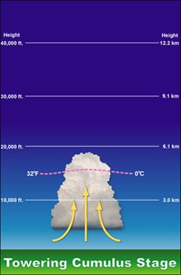
There are three basic stages of thunderstorm development: the updraft cumulus stage, the mature stage and the dissipating stage. The lifecycle of a thunderstorm cell going through these stages is, on average, about 30-40 minutes.
The first stage of thunderstorm development is the updraft (cumulus) stage. In this stage, the primary activity within the cell is pronounced vertical uplift. Warm moist air is lifted adiabatically and condenses to form cumulus-type cloud formations. As the updraft stage continues, the formation of towering cumulus begins. Little or no precipitation occurs during this stage.

The second stage of thunderstorm development is the mature stage that is characterized by both updrafts and downdrafts. Downdrafts are associated with air that is pulled downward by precipitation. Normally downdrafts will be found near the leading edge of the thunderstorm cell. The air descending from the thunderstorm will often hit the ground and be forced out ahead of the cell creating a gust front. In the Arizona desert region, these gust fronts will pick up large quantities of dust and/or sand creating a dust wall. The common desert term for such a phenomenon is haboob.

The final stage of thunderstorm lifecycle is the dissipating stage. This usually occurs when a large amount of precipitation has been produced and the storm becomes dominated by downdrafts and weak updrafts in the upper regions of the thunderstorm. At the groundlevel, the gust front moves out over a long distance from the storm and cuts off the storm's inflow. This begins the dissipating stage of the thunderstorm. Even though this thunderstorm has dissipated, its gust front may trigger new thunderstorms as it lifts warm, moist, unstable air. Eventually, when storm has completely weaken it begins to lose it shape often leaving only the top anvil remnants of the storm and debris clouds

The terms below are usually associated with our Summer Thunderstorms
Haboob: - A lens-shaped dust wall generated from surface outflow (see downbust) from a mature thunderstorm cell. The name comes from the Arabic word habb, meaning "wind." Haboobs are most frequent in SW North America during the month os May through September, with most frequent occurrence in June, but they can occur in every month. Their average duration is less than three hours. The average maximum wind velocity is over 30 mph and dust may raise to heights exceeding 3000 feet. This nice image of a haboob on 30 July 1995 was captured by AZTC member John Moore during one of our missions:

Downbust - Localized pockets of intense downdrafts can create severe weather conditions called "downbursts" . A "downburst" is a strong downdraft that induces an outward burst of damaging winds on or near the surface. Downbursts can be large, called a "macroburst" (2.5 miles or large outflow diameter and damaging winds lasting 5 to 20 minutes) or small, called a "microburst" (less than 2.5 miles outflow diameter with peak winds lasting only 2 to 5 minutes). Therefore, "macrobursts" and "microbursts" are severe conditions of downdrafts.

Cross section of a conceptual vortex ring model of a microburst (Caracena, 1982; 1987). (From: Microbursts: A Handbook for Visual Identification by Caracena, et al., 1989)
All downbursts are characterized by a circulation termed a "vortex ring", a vertically rotating circle of air. Downdrafts can be dry or wet. A dry "downburst" is more common during the climatologically drier times of the Arizona monsoon (June & early July), while a wet "downburst" prevails during the wetter times of the monsoon, statistically in late July through September.
Dry downbursts will not necessarily show a solid perturbation from the base of the cloud to the characteristic curl. Instead, a dry downburst is generally only visible when the vertically descending winds hit the ground and pick up substantial quantities of dust. These types of downbursts are common in Arizona and will be particularly evident during the early portion of the monsoon season when there is still little precipitation associated with thunderstorms.

Dry Monsoon Thunderstorm Schematic
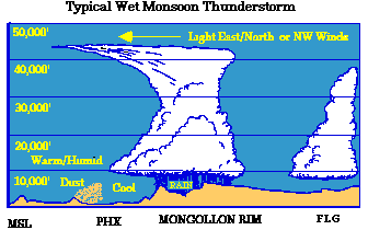
Wet downbursts, on the other hand, have the characteristic precipitation curl tracing out the vortex-ring circulation that surrounds the concentrated downdraft within the rain shaft. Most wet downbursts will describe a "foot shape" as the strong vertical winds carrying precipitation hit the ground and curl upwards.

Wet Monsoon Thunderstorm Schematic
Gustnadoes and Dust Devils
Gustnadoes - Are features that seem to combine some of the characteristics of dust devils) and tornadoes. In essence, a gustnado is a tornado-like vortex that appears to develop on the ground and extend several hundred feet upward. These vortices generally develop along the leading edge of an outflow boundary from a thunderstorm cell. Although generally of limited duration, the winds of gustnadoes can be strong enough to cause damage. Gustnadoes are often mis-identified as fires.
For example, associated with the photograph below, team members identified a gustnado occurring along an outflow boundary near the town of Guadalupe. Upon arrival in the Guadalupe area, no evidence of the feature was seen but follow-up discussion with the Guadalupe Fire Department found that the Fire Department had been called out in response to a report of "a downed airplane that caused a huge fire just south of town". They had been unable to find any fire (or downed plane) and were relieved when we informed them that the feature had been a gustnado. Additonal Photographic imagery taken by AZTC chaser John Moore of the 12 July 1995 gustnado can be found at: AZ Gustnado 1995

Figure showing the Guadalupe AZ gustnado cirra 1998
Dust Devils. A dust devil is a vortex of dust-filled air created by extreme surface heating. Diameters range from 10 feet to greater than 100feet; their average height is between 500 and 1000 feet but can extend to several thousand feet. They display some characteristics similar to tornadoes: both cyclonic and anticyclonic dust devils have been observed and large dust devils have been observed with accompanying "suction vortices" (smaller dust devils rotating around the main vortex).
Tornadoes
Tornadoes - Luckily, severe tornadoes are fairly rare in Arizona. Although we have many of the weather features (such as abundant moisture, superadiabatic heating, etc.) needed to create thunderstorms of sufficient severity to produce tornadoes, only rarely do we have them all at the same time. In particular, we often during the summer time fail to have a strong jet stream (a narrow corridor of very strong winds generally found about 6 miles up in the atmosphere) overhead. A jet stream often acts as a super vacuum (creating convergence at the surface) as it aids in sucking up the air from the ground.
However, tornadoes have occurred in Arizona and will occur in the future. In particular, during severe thunderstorms (particularly in the cold-front produced thunderstorms of the fall) we will see what is often termed by the media cold air funnels. A cold air funnel is quite simply a funnel cloud, vortex of spinning air. If a cold air funnel cloud extends down to the ground, it becomes a tornado. In other words, a cold air funnel is a potential tornado and must be treated as such. A funnel cloud should not be taken lightly as any funnel cloud has the potential to become a tornado.
Tornado Safety
(1) DO NOT ATTEMPT TO OUTRUN IT. Tornadoes may not move at all... or .... they can, on occasion, move incredibly fast .... 50 mph or more (this is most likely during the fall and winter storms in Arizona). Don't risk outrunning it!
(2) If caught out in the open, proceed to the lowest place (e.g., a ditch, or culvert or arroyo) and drop flat to the ground. Of course, watch for flash flooding!
(3) If caught out in your vehicle, ABANDON your vehicle and find the lowest place (ditch, culvert or arroyo).
(4) If in a building, head to the lowest floor, the center of the building and in the smallest room .. putting as many walls between you and the storm as possible. A bathroom is generally considered a good safety area given the number of pipes in the walls of the building.
Winds
Winds - Although tornadoes are rare in Arizona, strong winds resulting from downbursts are quite common during the summer thunderstorm season in the desert. Desert storm chasers should be prepared to estimate distant winds. You should realize there is a natural tendency to overestimate wind speeds from observations.
Guide Estimating Wind Speeds
(adapted from Beaufort Wind Scale for Land Wind Observations, Smithsonian Meteorological Tables)

Storm Spotter Training - The first phase of training is a series of spotter training sessions presented by National Weather Service personnel and members of the Office of Climatology at Arizona State University. Spotter training involves: (a) visual recognition of environmental signatures commonly associated with on-going and/or developing severe thunderstorms (Caracena et al. 1989) and (b) identification of the specific kinds of meteorological criteria necessary to properly assess severe thunderstorm potential; e.g., wind gusts, hail size, or damage patterns (National Weather Service Operations Manual C40, 1990). Specific training is given in observing and evaluating visually unique or distinct atmospheric phenomena in the Southwest United States such as dust walls, dust devils, and eddies or vortices associated with down bursts (Caracena et al. 1989; Fujita 1985). Much of this training complements existing severe storm spotter programs such as the Arizona Skywarn Amateur Radio Network. The spotter training uses the materials and follows the type of instruction suggested by the National Weather Service (Moller 1978). An excellent on-line stormspotters guide can be found at the following URL: NSSL Stormspotter Guide
A good glossary for weather and storm-chasing terminology is available at: Pepper Ridge North Valley's Weather Glossary
Additional monsoon information can be found on the Monsoon Page.
Resources: NWS Tucson Arizona, University of Arizona College of Atmospheric Sciences and Arizona State University's Geographic Sciences Dept
|

 New Feature


