Welcome to the Pepper Ridge North Valley's
Severe Weather Page
This is your weather warning resource page. Check this page for the latest watches and warning updates,
from The National Weather Service, Phoenix, Az.!
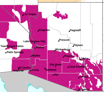
MAP OF CURRENT SOUTHWEST WATCHES, WARNINGS AND ADVISORIES
Local & Regional Weather Statements, Watches And Warnings
Weather Alerts for Graham/Greenlee CountiesIssued by the National Weather Service |
BLOWING DUST ADVISORY  |
GRAHAM/GREENLEE COUNTIES |
Areas Affected: Eastern Cochise County Below 5000 Feet including Douglas/Willcox - Upper Gila River and Aravaipa Valleys including Clifton/Safford |
Effective: Fri, 2/14 1:10am |
Updated: Fri, 2/14 6:22pm |
Urgency: Expected |
Expires: Fri, 2/14 7:00pm |
Severity: Moderate |
Certainty: Likely |
|
Details:
* WHAT...For the Wind Advisory, southwest to west winds 25 to 30 mph
with gusts 40-45 mph. For the Blowing Dust Advisory, visibility
between one and three miles in blowing dust. Localized areas in
dust prone areas near the Willcox Playa and along Interstate 10
between the Willcox Playa and the Arizona and New Mexico state
border may experience one-quarter to one mile visibility in dense
blowing dust.
* WHERE...Eastern Cochise County below 5000 feet and Upper Gila
River Valley.
* WHEN...From noon today to 7 PM MST this evening.
* IMPACTS...Hazardous driving conditions due to reduced visibility.
Gusty winds will blow around unsecured objects. Tree limbs could
be blown down and a few power outages may result.
Information:
Persons with respiratory problems should make preparations to stay
indoors until the storm passes. Be ready for a sudden drop in
visibility to near zero. If you encounter blowing dust or blowing
sand on the roadway or see it approaching, pull off the road as far
as possible and put your vehicle in park. Turn the lights all the
way off and keep foot off the brake pedal. Remember, 'Pull Aside,
Stay Alive'.
Winds this strong can make driving difficult, especially for high
profile vehicles. Use extra caution. |
WIND ADVISORY  |
GRAHAM/GREENLEE COUNTIES |
Areas Affected: Upper San Pedro River Valley including Sierra Vista/Benson - Galiuro and Pinaleno Mountains including Mount Graham - Chiricahua Mountains including Chiricahua National Monument - Dragoon/Mule/Huachuca and Santa Rita Mountains including Bisbee/Canelo Hills/Madera Canyon |
Effective: Fri, 2/14 1:10am |
Updated: Fri, 2/14 6:22pm |
Urgency: Expected |
Expires: Fri, 2/14 7:00pm |
Severity: Moderate |
Certainty: Likely |
|
Details:
* WHAT...Southwest to west winds 25 to 35 mph with gusts 40-45 mph
expected.
* WHERE...Chiricahua Mountains, Dragoon and Mule and Huachuca and
Santa Rita Mountains, Galiuro and Pinaleno Mountains, and Upper
San Pedro River Valley.
* WHEN...From noon today to 7 PM MST this evening.
* IMPACTS...Gusty winds will blow around unsecured objects. Tree
limbs could be blown down and a few power outages may result.
Information:
Winds this strong can make driving difficult, especially for high
profile vehicles. Use extra caution. |
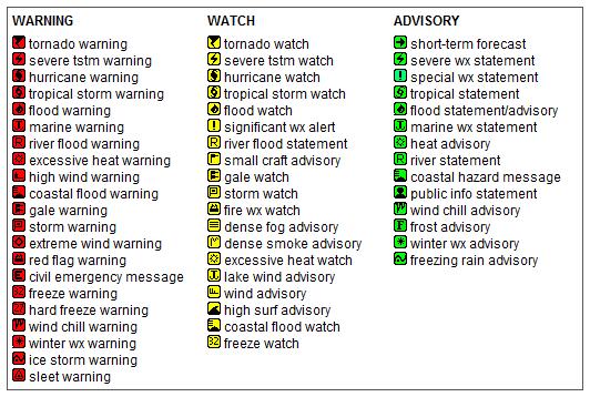
Key to Icons for Local & Regional Weather Statements, Watches And Warnings
Map of the Current Watches, Warnings, and Advisories Nationwide:
|
|
Member of the:

|
North Valley Random Weather Facts |
HUMIDEX
Definition Humidex - Over the years, several measures have been proposed to relate various combinations of temperature and humidity into a single number to approximate what hot, humid weather feels like to the average person. Of these, humidex is the one most familiar to Canadians. Humidex was introduced into Canada in 1965. The index is a summer analogue of the wind chill factor in that it is an equivalent air temperature. Air of a given temperature and humidity is equated in comfort to air of a higher temperature that has a negligible moisture content. Comfort is quite subjective and largely dependent on the age and health of the individual. Weather conditions causing prickly heat in an infant may result in heat cramps in a teenager, heat exhaustion in a middle-aged and heat stroke in a senior. Humidex is also limited as an overall hot-weather comfort index because it does not consider other factors such as pressure, wind speed, precipitation, sunshine or pollen.
Get the Facts PHP
|
|
Page layout last updated on Mar 8th, 2024
|
|
|