Skip to main content.
Currently:94.7°F Mainly cloudy, Dry
Mainly cloudy, Dry
Comfort Index: ---
 Updated21-Jul-2026 2:00pm @ 
 
Time of Next Full Update: 2:05 pm -  Station Elev: 1469 ft  
Pepper Ridge North Valley - Navigation Menu
Pepper Ridge North Valley - Main Naviagation Menu

Weather Links:

       Home Page 

      Current Weather 

           Forecast Page 

          Historical Data

           Live Lightning 

            Monsoon Info 

        Satellite/Radar 

       Station Info

     Tropical Weather

        Weather Ed. 101 

          Weather Links 

      Weather Photos 

  Weather Warnings

       More Wthr Links 

Us Flag

New FeatureNew Feature
N.O.A.A Radio

Celebrating
20 Years on the web
2005 - 2025

& 25+ Years of Data
1997 - 2025
At Pepper Ridge

 Weather Reports: 
Monsoon 2025New Feature
 Highlights. 

Monsoon 2024
 Highlights. 

Monsoon 2025New Feature
 Wrap Up Review. 

Monsoon 2021
 Wrap Up Review. 


Lower Sidebar Page
Pepper Ridge Weather Station
USA Weather Finder
Wunderground

Sky Warn

CWOP 3794 Quality Control Logo
CW 3794

For more information
about this site
contact the
Web Master

Willow Fire Pyro Cumulus Cloud

Return to Top
of Page

Welcome to the Pepper Ridge North Valley's
Severe Weather Page

This is your weather warning resource page. Check this page for the latest watches and warning updates, from The National Weather Service, Phoenix, Az.!


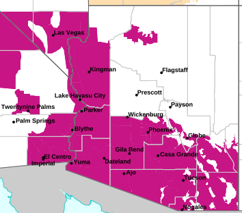
MAP OF CURRENT SOUTHWEST WATCHES, WARNINGS AND ADVISORIES

Current Active Arizona Watches,
Warnings and Advisories

Severe Weather Warnings Map

Phoenix Warnings Flagstaff Warnings Tucson Warnings Las Vegas Warnings

Image credit: NWS, Phoenix, Arizona


Forcasts, Outlooks & Statements:

Short Term Forecast
Special Weather Statement
Flood Statement
Hazardous Weather Outlook

Watches, Warnings & Advisories:

Snow Advisory
Snow And Blowing Snow Advisory
Freezing Rain Advisory
Winter Storm Advisory
Winter Storm Watch
Winter Storm Warning
Heavy Snow Warning
Freeze Watch
Freeze Warning
Wind Advisory
High Wind Watch
High Wind Warning
Heat Advisory
Excessive Heat Warning
Fire Weather Watch
Red Flag Warning
Flash Flood Watch
Flash Flood Warning
Severe ThunderStorm Watch
Severe ThunderStorm Warning
Tornado Watch
Tornado Warning


Local & Regional Weather Statements, Watches And Warnings
Weather Alerts for Yavapai County

Issued by the National Weather Service

Flood Watch  FLOOD WATCH   Flood Watch
YAVAPAI COUNTY

Areas Affected:
Kaibab Plateau - Marble and Glen Canyons - Grand Canyon Country - Coconino Plateau - Yavapai County Mountains - Northeast Plateaus and Mesas Hwy 264 Northward - Little Colorado River Valley in Coconino County - Little Colorado River Valley in Navajo County - Little Colorado River Valley in Apache County - Western Mogollon Rim - Eastern Mogollon Rim - White Mountains - Northern Gila County - Yavapai County Valleys and Basins - Oak Creek and Sycamore Canyons - Black Mesa Area - Northeast Plateaus and Mesas South of Hwy 264
Effective: Tue, 7/21 4:04am Updated: Tue, 7/21 2:03pm Urgency: Future
Expires: Tue, 7/21 10:00pm Severity:  Severe  Certainty: Possible

 
Details:
* WHAT...Flash flooding caused by excessive rainfall continues to be
possible.

* WHERE...Yavapai County, Coconino County, northern Gila County,
Navajo County, central and southern Apache County.

* WHEN...From 11 AM MST  /noon MDT/ this morning through this
evening.

* IMPACTS...Flash flooding will be possible in creeks, normally dry
washes, swimming holes, and over recently burned areas. Raging
killer currents will be possible in side canyons and narrow slot
canyons. Low-water crossings may be flooded.

* ADDITIONAL DETAILS...
- Deep monsoon moisture in place across northern Arizona will lead
to storms capable of producing rainfall in excess of 2 inches per
hour, resulting in an enhanced risk of flash flooding.
- Additional information is available at weather.gov/flagstaff.

Information:
Have a way to receive Flash Flood Warnings and be prepared to take
action should warnings be issued.

Consider changing your plans if you were going to hike, boat, or
paddleboard to a slot canyon or normally dry wash. If you do still
decide to recreate, check in at a nearby visitor center or ranger
station.


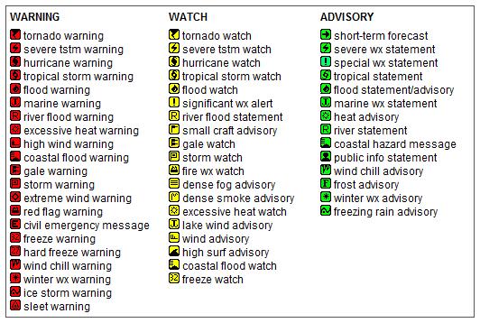
Key to Icons for Local & Regional Weather Statements, Watches And Warnings

Alerts Key

Map of the Current Watches, Warnings, and Advisories Nationwide:

national advisories

Member of the:
LightningRing
World Weather Websites

 North Valley Random Weather Facts

DEW POINT
Dew point is the temperature to which air must be cooled for saturation (100% relative humidity) to occur. The dew point is an important measurement used to predict the formation of dew, frost, and fog. If dew point and temperature are close together in the late afternoon when the air begins to turn colder, fog is likely during the night. Dew point is also a good indicator of the air's actual water vapor content, unlike relative humidity, which takes the air's temperature into account. High dew point indicates high vapor content; low dew point indicates low vapor content. In addition a high dew point indicates a better chance of rain and severe thunderstorms. You can even use dew point to predict the minimum overnight temperature. Provided no fronts or other weather pattern changes are expected overnight, the afternoon's dew point gives you an idea of what minimum temperature to expect overnight.

Get the Facts PHP


Page layout last updated on Mar 8th, 2024