Welcome to the Pepper Ridge North Valley's
Severe Weather Page
This is your weather warning resource page. Check this page for the latest watches and warning updates,
from The National Weather Service, Phoenix, Az.!
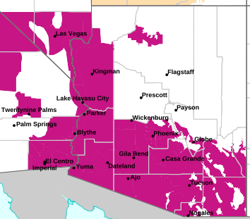
MAP OF CURRENT SOUTHWEST WATCHES, WARNINGS AND ADVISORIES
Local & Regional Weather Statements, Watches And Warnings
Weather Alerts for Lake Havasu/Fort Mohave & Lake Mead Nat Recreation AreaIssued by the National Weather Service |
HIGH WIND WATCH  |
| LAKE HAVASU/FORT MOHAVE & LAKE MEAD NAT RECREATION AREA |
Areas Affected: Lake Havasu and Fort Mohave - Lake Mead - AZ side - Lake Mohave - AZ side - Eastern Sierra Slopes of Inyo County - White Mountains of Inyo County - Death Valley National Park - Eastern Mojave Desert, Including the Mojave National Preserve - Morongo Basin - Cadiz Basin - San Bernardino County-Upper Colorado River Valley - Owens Valley South - Owens Valley North - Esmeralda and Central Nye County - Lincoln County - Northeast Clark County - Western Clark and Southern Nye County - Sheep Range - Spring Mountains-Red Rock Canyon - Las Vegas Valley - Southern Clark County - Lake Mead - NV side - Lake Mohave - NV side |
| Effective: Fri, 5/15 2:08pm |
Updated: Fri, 5/15 5:13pm |
Urgency: Future |
| Expires: Sat, 5/16 4:00am |
Severity: Severe |
Certainty: Possible |
|
Details:
* WHAT...Northwest winds 25 to 35 mph with gusts between 50 and 60
mph possible.
* WHERE...Portions of northwest Arizona, southeast California, and
south central and southern Nevada.
* WHEN...From Sunday morning through late Sunday night.
* IMPACTS...Damaging winds could blow down trees and power lines.
Widespread power outages are possible. Travel could be difficult,
especially for high-profile vehicles. Blowing dust and reduced
visibility is possible.
Information:
Monitor the latest forecasts and warnings for updates.
Fasten loose objects or shelter objects in a safe location prior to
the onset of winds.
Strong winds and rough waves on area lakes will create hazardous
conditions for small craft. |
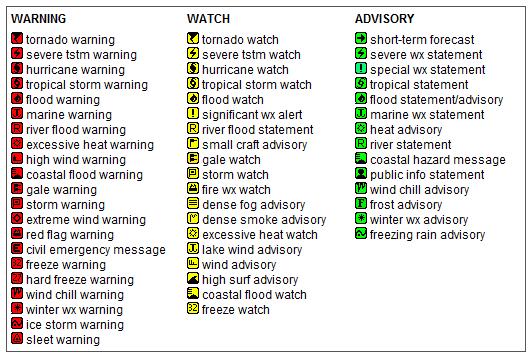
Key to Icons for Local & Regional Weather Statements, Watches And Warnings
Map of the Current Watches, Warnings, and Advisories Nationwide:
|
|
Member of the:

|
North Valley Random Weather Facts |
CLOUD HEIGHT
The cloud height on this site is an estimate of cumulus clouds using a formula based on temperature and dew point. Actual measurements of cloud height are made with a Micropulse Lidar (MPL). This device fires a laser into the sky and measures the backscattered signal. Costs for such a device are beyond the scope of weather hobbyists.
Get the Facts PHP
|
|
Page layout last updated on Mar 8th, 2024
|
|
|