|
Severe Thunderstorms
in Arizona
Stormy Weather!
Severe thunderstorms
are fairly common during the monsoon in Arizona. Strong downburst
winds, flash flooding and
cloud-to-ground lightning are the most frequently observed thunderstorm
phenomena but hail, blowing dust and
even an occasional small tornado can also be observed.
Weather Patterns
Associated with Severe Thunderstorms.
The Type I - Southern Plains/Four Corner High - pattern
is the "classic" monsoon pattern. The streamlines depicted below
are for the mid-levels or about 20,000
feet above sea level. In this situation the monsoon ridge sets up over the southern Plains. This broad high is positioned across the southern
half of the United States with easterly flow
located over portions of Texas, New Mexico and extends west to the Arizona-Utah border The Easterly flow in Mexico and a more Southeasterly flow into Arizona means lots a of thunderstorms in the mountains and Southern Eastern Arizona foothills. A secondary high usually develops near the Four-Corner region. When this happens, mid level temperatures across southern Arizona cool, low level moisture increases from the south or east, and winds between 10,000 and 20,000 feet increase out of the east. This causes thunderstorms to tilt slightly, and allows them to maintain themselves for longer periods of time while organizing into lines or clusters. If the lower levels of the atmosphere are rather dry, straight line winds and dust storms are a major concern. If the lower levels are moist, flash flooding becomes a problem as well. Strong High pressure over the
southwest United States almost guarantees that
the surface based thermal low is deepening (refer to the Gulf Surge
discussion).
Initially, thunderstorms on Type-I days form on the mountains and spread east-to-west or southeast-to-northwest. Thunderstorms on the Mogollon Rim and in the White Mountains tend to remain where they develop, while the storms in the mountains of southeast Arizona or northern Sonora tend to move into the valleys and eventually the low deserts. As these storms move progressively farther to the north or the west, they typically encounter a more stable atmosphere and dissipate. When a Gulf Surge is underway, though, the atmosphere remains unstable as the storms move into the lower deserts. In these instances, storms may continue to travel all the way to the Colorado River Valley.

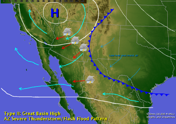
The Type II: Great Basin High -
pattern is associsted with a high amplitude ridge over the western
United States. The streamlines indicate that easterly to northeasterly
flow is located across Arizona with this pattern. Once again
all the elements are there, easterly flow over Mexico for lots of
storms and intense heat over the west building the surface
based thermal low. Over the eastern U.S., an unusually deep upper level trough develops which sometimes pushes a cold front south through the Plains and west toward the Arizona-New Mexico border. With this pattern the ocscasional weak cool fronts can actually bring moisture from the High Plains into Arizona.The clockwise circulation around the upper level high causes winds between 10,000 and 18,000 feet increase out of the northeast over Arizona.
As the thunderstorms develop on the mountains, the Mogollon Rim readily forces them to organize into squall lines, which are then pushed southwest by the winds aloft into the deserts. The northeast winds aloft usually bring drier air into Arizona, so if the drying is deep enough, the thunderstorms may dissipate before moving very far away from the higher terrain. However, if there is only drying aloft and low level moisture remains plentiful, the downdrafts associated with these lines of storms can become large and severe. Areas most susceptible to Type II events are those immediately downwind from the Rim or White Mountains of east central Arizona, including: the Phoenix Metro Area, the Gila River Valley, and the valleys of Yavapai County. The changing wind direction and speed with height also helps to sustain the thunderstorms for even longer periods than in Type-I patterns, which can allow them to persist well into the night as they move southwest through Tucson and the Colorado River Valley.

The Type III: Trapping High -
pattern is also associated with active periods of the monsoon. The
elements are similar to the previous
two pattern types easterly flow over northwest Mexico with hot temperatures
across Arizona by virtue of
there being a high pressure system nearly directly overhead. Typically below 20,000
feet the This pattern is quite different than the other two in that the monsoon ridge is weaker and sometimes suppressed father to the south - sometimes extending along the U.S.-Mexican border. The ridge will sometimes break into two separate centers with one over south Texas and the other over northern Baja. If this occurs either in June or September, the ridge placement tends to block moisture coming north from Mexico. However during monsoon peak, moisture still finds its way into Arizona from the south and east. Meanwhile, upper level disturbances can move into the region from several different directions, and either slow down, or become trapped within the ridge and stall. The presence of a weak upper low keeps temperatures aloft relatively cool, and the entire atmosphere unstable.

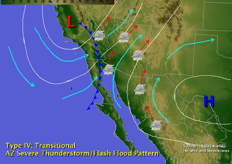
Type IV: Transitional -
This pattern does not need the monsoon itself to generate severe weather in Arizona. It tends to develop sometime in late August or early September, and usually acts on moisture that was transported into Arizona during the monsoon season. This pattern is called "transitional" because winds aloft shift from the tropical easterlies back to the southwest or west. This typically happens as the subtropical high weakens and shifts southeast into northern Mexico or the Gulf of Mexico, and a trough of low pressure develops near the West Coast. This trough is sometimes accompanied by a weak surface cold front, which helps to organize thunderstorms development.
Surface winds ahead of these upper level troughs usually remain out of the south or southeast, while upper level winds shift to the southwest or west. The resulting wind shear can cause squall lines, or rotating, supercell thunderstorms to develop. This pattern is actually similar to the conditions that trigger severe weather in the Great Plains during the spring and summer. Tornadoes are uncommon in Arizona, but this is the one pattern most likely to support stronger ones, especially from the Phoenix area north into the Rim Country and along the Utah border. Large hail can also be a problem in these situations, in addition to the damaging winds. Type-IV patterns can also cause flash flooding if the front moves slowly, or if the front taps into a tropical system well to the south. Type-IV patterns are also the most common pattern to import Tropical moisture from Eastern Pacific Hurricanes with the pattern being common in latest summer/early fall when Eastern Pacific Hurricanes frequently impact the Baja California coast. On rare ocassions the actual tropical cirriculation of Tropical system surrives the journey across the Baja and remains intact as it enters the Desert Southwest. Once the trough and associated cold front passes through Arizona, dry westerly flow at all levels of the atmosphere usually overspreads the region. After a Type-IV event, the weather usually turns quiet across Arizona for several days, and may even signal the end of the monsoon.

Why are Some
Storms Severe?
A downburst
is a concentrated area of strong winds in the vicinity of a thunderstorm.
When conditions are right downburst winds can attain speeds of over
100 mph! This is more than enough to lift a roof, roll a mobile
home or bring
down power lines. luckily downburst with wind speeds greater than
100 mph are rare. More typical are wind speeds
of 40 to 50 mph. The main ingredients for a severe downburst (58
mph or greater) are an above average high temperature,
low relative humidity and above average total moisture in the layer
underneath the developing thunderstorm.
When these three ingredients combine severe downbursts are usually
the result.

When the atmosphere
is extremely moist any individual storm is capable of producing
localized flooding. This occurs
when very moist air ascends, forms a thunderstorm and produces an
extremely intense rain shaft. This is a fairly
common occurrence in southeast Arizona during the monsoon.

A flash flood
producing thunderstorm is usually more organized than the garden
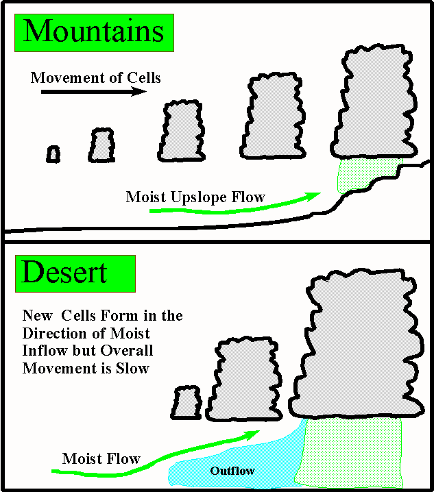
variety heavy downpour. Flash flood producing storms can be classified as mountain slope or desert valley flash flood storms.
In the mountain
slope storms moisture laden flow is upslope towards the mountains.
The moist flow destabilizes as it
moves up the mountain slope forming a series of thunderstorms. One
thunderstorm cell after another will form and move
over the same area. This results in rapid runoff which can travel
many miles beyond the direct influence of thunderstorm activity.
In the desert
valley flash flood storm a different mechanism is at work. Like
the mountain slope storm there is moist low
level flow. As thunderstorms initiate within this moist flow thunderstorm
outflows form a boundary at the surface.
This boundary acts as a focusing mechanism for further thunderstorm
development. Typically new cell developemnt will be toward the low-level
inflow with a succesion of new storms forming and moving over the
same area.
Some of the most damaging and severe flash floods in Tucson have
been a direct result of the desert valley flash
flood type storm.

Of course with
any strong thunderstorm frequent cloud-to-ground lightning is common
and when conditions are right
severe downburst wind and flash flooding can accompany a thunderstorm
outbreak. Large hail, blowing dust and
even small tornadoes all can result when the atmosphere over southeast
Arizona becomes very unstable.
Back to monsoon
page
|

 New Feature


