Welcome to Pepperridge North Valley's
Current Weather Trends Page
|
Current Trends Over The Last 60 Minutes
|
Trends as of 24-Aug-2026
at
6:10am
| TIME |
TEMP
°F |
WIND SPEED
mph |
WIND GUST
mph |
WIND DIR
|
HUMIDITY
% |
PRESSURE
inHg |
RAIN
in |
| Current |
86.4 |
0.0 |
0.0 |
S |
46 |
29.858 |
0.00 |
| 5 minutes ago |
86.3 |
0.0 |
0.0 |
S |
47 |
29.857 |
0.00 |
| 10 minutes ago |
86.3 |
0.0 |
0.0 |
S |
47 |
29.857 |
0.00 |
| 15 minutes ago |
86.3 |
0.0 |
0.0 |
S |
47 |
29.856 |
0.00 |
| 20 minutes ago |
86.2 |
0.0 |
0.0 |
S |
47 |
29.854 |
0.00 |
| 30 minutes ago |
86.1 |
0.0 |
0.0 |
S |
47 |
29.858 |
0.00 |
| 45 minutes ago |
86.2 |
0.0 |
0.0 |
S |
46 |
29.858 |
0.00 |
| 60 minutes ago |
86.4 |
0.0 |
0.0 |
S |
46 |
29.854 |
0.00 |
| 75 minutes ago |
86.6 |
0.0 |
0.0 |
S |
46 |
29.849 |
0.00 |
| 90 minutes ago |
87.0 |
0.0 |
0.0 |
S |
46 |
29.853 |
0.00 |
| 105 minutes ago |
87.7 |
0.0 |
0.0 |
SW |
44 |
29.849 |
0.00 |
| 120 minutes ago |
87.5 |
0.0 |
0.0 |
N |
42 |
29.846 |
0.00 |
Records and Stats
| RAIN |
RAIN HISTORY |
| Today |
0.00 in
(0.00 in last hour) |
Today |
3 days since last rain on
20-Aug-2026 3:52am |
| Yest. |
0.00 |
Week |
0.18 in over last 7 days. |
| Month |
1.15 (5 rain days this month) |
Month |
0.69 in last month. |
| Year |
2.60 (
18 rain days this year) |
Year |
4.47 in total last year at this time. |
| TEMPERATURE HIGHS |
HOT DAYS THIS MONTH |
| Today |
90.4 °F at 12:02am |
Max > 86 °F |
24 days |
| Yest. |
109.4 °F at 2:33pm |
Max > 77 °F |
24 days |
| Month |
112.8 °F on
01-Aug-2026 |
Warmest day |
111.7 °F on 01-Aug-2026 |
| Year |
113.7 °F on
24-Jul-2026 |
Warmest night |
100.0 °F on 03-Aug-2026 |
| TEMPERATURE LOWS |
COLD DAYS THIS MONTH |
| Today |
86.1 °F at 5:27am |
Min < 32 °F |
0 days |
| Yest. |
87.1 °F at 6:11am |
Min < 5 °F |
0 days |
| Month |
74.7 °F on
12-Aug-2026 |
Coldest day |
89.2 °F on 13-Aug-2026 |
| Year |
33.3 °F on
10-Jan-2026 |
Coldest night |
77.5 °F on 13-Aug-2026 |
| BAROMETER HIGHS |
HEAT INDEX HIGHS |
| Today |
29.879 inHg at 1:02am |
Today |
90.3 °F at 12:04am |
| Yest. |
29.886 inHg at 11:21pm |
Yest. |
113.7 °F at 2:59pm |
| Month |
29.961 inHg on
15-Aug-2026 |
Month |
117.5 °F on
03-Aug-2026 |
| Year |
30.558 inHg on
10-Jan-2026 |
Year |
121.6 °F on
24-Jul-2026 |
| BAROMETER LOWS |
WIND CHILL LOWS |
| Today |
29.795 inHg at 1:55am |
Today |
86.1 °F at 5:27am |
| Yest. |
29.700 inHg at 5:26pm |
Yest. |
87.1 °F at 6:11am |
| Month |
29.503 inHg on
03-Aug-2026 |
Month |
74.7 °F on
12-Aug-2026 |
| Year |
29.503 inHg on
03-Aug-2026 |
Year |
33.3 °F on
10-Jan-2026 |
| EVAPOTRANSPIRATION |
RAIN |
| Today |
0.02 in |
Today |
0.00 in |
| Yest. |
0.240 in |
Yest. |
0.00 |
| Month |
5.52 in |
Month |
1.15 |
| SOLAR HIGHS |
UV HIGHS |
| Today |
0 W/m2 at 12:00am |
Today |
0.0 index at 12:00am |
| Yest. |
923.0 W/m2 at 11:34am |
Yest. |
4.6 index at 12:17pm |
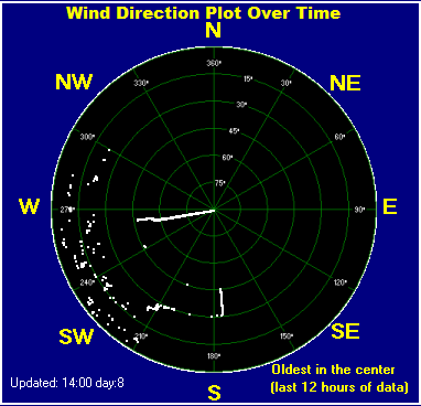
Wind Data
| CURRENT |
 |
| Now |
0.0 mph S |
| Gust |
0.0 mph S |
| Gust/hr |
0.0 mph |
| WIND GUST HIGHS |
| Today |
9.2 mph NNW at 12:29am |
| Yest. |
18.4 mph at 5:33pm |
| Month |
41.4 mph on
19-Aug-2026 |
| Year |
42.6 mph on
13-Jul-2026 |
| WIND GUST AVERAGE HIGHS |
| Today |
3.7 mph N at
1:33am |
| Yest. |
10.8 mph at 5:35pm |
| Month |
30.0 mph on
19-Aug-2026 |
| Year |
30.0 mph on
19-Aug-2026 |
| WIND RUN |
| Today |
0.25 miles |
| Month |
41.65 miles |
| Year |
274.29 miles |
|
Member of the:


|
Pepper Ridge North Valley Random Weather Facts |
HUMIDEX
Definition Humidex - Over the years, several measures have been proposed to relate various combinations of temperature and humidity into a single number to approximate what hot, humid weather feels like to the average person. Of these, humidex is the one most familiar to Canadians. Humidex was introduced into Canada in 1965. The index is a summer analogue of the wind chill factor in that it is an equivalent air temperature. Air of a given temperature and humidity is equated in comfort to air of a higher temperature that has a negligible moisture content. Comfort is quite subjective and largely dependent on the age and health of the individual. Weather conditions causing prickly heat in an infant may result in heat cramps in a teenager, heat exhaustion in a middle-aged and heat stroke in a senior. Humidex is also limited as an overall hot-weather comfort index because it does not consider other factors such as pressure, wind speed, precipitation, sunshine or pollen.
Get the Facts PHP
|
|
Page layout last updated on Feb 25th, 2010




 New Feature