Skip to main content.
Currently:88.3°F Night time, Dry, Clear skies
Night time, Dry, Clear skies
Comfort Index: ---
 Updated17-Jun-2026 4:15am @ 
 
Time of Next Full Update: 4:20 am -  Station Elev: 1469 ft  
Pepper Ridge North Valley - SWN Navigation Menu
Pepper Ridge North Valley - Main Naviagation Menu

Weather Links:

       Home Page 

      Current Weather 

           Forecast Page 

          Historical Data

           Live Lightning 

            Monsoon Info 

        Satellite/Radar 

       Station Info

     Tropical Weather

        Weather Ed. 101 

          Weather Links 

      Weather Photos 

  Weather Warnings

       More Wthr Links 

Us Flag

New FeatureNew Feature
N.O.A.A Radio

Celebrating
20 Years on the web
2005 - 2025

& 25+ Years of Data
1997 - 2025
At Pepper Ridge

 Weather Reports: 
Monsoon 2025New Feature
 Highlights. 

Monsoon 2024
 Highlights. 

Monsoon 2025New Feature
 Wrap Up Review. 

Monsoon 2021
 Wrap Up Review. 


Side Bar Php

Current Conditions

@ 17-Jun-2026 4:15am
88.3°F Colder 1.4°F than last hour.
Temp Change: °F /hr
Night time, Dry, Clear skies  Night time, Dry, Clear skies
Feels Like: 89 °F
Humidity: 41%Increased 2% since last hour.
Dew Point: 61.6 °FIncreased 0.1°F since last hour.
Wind: Calm
---

 mph
Gust: 0.0 mph
Pressure: 29.64 in Rising 0.016 inHg/hour
Rising slowly
Solar Rad: 0%
0 W/m2
UV Index: 0.0
None
Rain Today: 0.00 in
Rain Rate: 0.000 in
Rain Month: 0.00 in
Rain Year: 0.72 in

Almanac

Sunrise: 5:17 am
Sunset: 7:40 pm
Moonrise: 7:59 am
Moonset: 9:43 pm
Waxing Crescent Moon
Waxing Crescent Moon, Moon age: 2 days,9 hours,22 minutes,6%
6%
Illuminated

Daily Min/Max

Today's High Temp: 92.6°F
1:42am
Today's Low Temp: 87.0°F
1:18am
Today's High Humidity: 41%
4:05am
Today's Low Humidity: 29%
12:00am
Today's High Dewpoint: 61.9°F
4:05am
Today's Low Dewpoint: 54.4°F
12:33am
Today's High Barometric Pressure: 29.641 in/Hg
3:58am
Today's Low Barometric Pressure: 29.618 in/Hg
2:08am
Today's High Wind Speed: 0.0 mph
2:46pm
Today's
High UV:
0.0
None
12:00am
Today's
High Solar:
0 W/m2
12:00am
Today's High Rain Rate: 0.000 in/min
2:00pm
Today's High
Hourly Rain Rate:
0.000 in/hr
Days Since
Last Rain:
98 Days

Current NWS Alerts:


Molokai Southeast/Windward
  Details for Molokai Southeast/Windward High Surf Advisory  +2 additional alerts
Big Island South
  Details for Big Island South High Surf Advisory  +1 additional alert
Kailua/Kona & Kohala
  Details for Kailua/Kona & Kohala High Surf Advisory  +1 additional alert
Kauai South
  Details for Kauai South High Surf Advisory  +1 additional alert
Maui Leeward
  Details for Maui Leeward High Surf Advisory  +1 additional alert
Maui Upcountry
  Details for Maui Upcountry High Surf Advisory  +1 additional alert
Haleakala Leeward/South
  Details for Haleakala Leeward/South High Surf Advisory  +1 additional alert
Molokai South/Leeward
  Details for Molokai South/Leeward High Surf Advisory  +1 additional alert
Honolulu Metro
  Details for Honolulu Metro High Surf Advisory  +1 additional alert
Waianae Coast & Mtns, Oahu
  Details for Waianae Coast & Mtns, Oahu High Surf Advisory  +1 additional alert
Big Island East/Hilo
  Details for Big Island East/Hilo Coastal Flood Statement
Big Island North
  Details for Big Island North Coastal Flood Statement
Kauai East/Lihue
  Details for Kauai East/Lihue Coastal Flood Statement
Kauai North/Princeville
  Details for Kauai North/Princeville Coastal Flood Statement
Maui Windward
  Details for Maui Windward Coastal Flood Statement
Haleakala Windward, Maui
  Details for Haleakala Windward, Maui Coastal Flood Statement
Molokai North & West
  Details for Molokai North & West Coastal Flood Statement
Oahu North Shore
  Details for Oahu North Shore Coastal Flood Statement
Olomana/Kaneohe
  Details for Olomana/Kaneohe Coastal Flood Statement
Koolau Windward, Oahu
  Details for Koolau Windward, Oahu Coastal Flood Statement
Kauai Coastal Waters
  Details for Kauai Coastal Waters Marine Weather Statement
Oahu Coastal Waters/Kaiwi Channel
  Details for Oahu Coastal Waters/Kaiwi Channel Marine Weather Statement
Maui Coastal Waters/Maalaea Bay
  Details for Maui Coastal Waters/Maalaea Bay Marine Weather Statement
Big Island Coastal Waters
  Details for Big Island Coastal Waters Marine Weather Statement

Lower Sidebar Page
Pepper Ridge Weather Station
USA Weather Finder
Wunderground

Sky Warn

CWOP 3794 Quality Control Logo
CW 3794

For more information
about this site
contact the
Web Master

Willow Fire Pyro Cumulus Cloud

Return to Top
of Page

Welcome to Pepperridge North Valley's
Hawaiian Satellite Page

ALOHA! Welcome to Paradise!

Enjoy These Photos from Hawaii - Click on picture for full Size View!

Byodo-In Temple in Kaneohe - Oahu
Byodo-In Temple in Kãne‘ohe - Oahu, Hi


Makapu'u Lighthouse - Oahu
Makapu'u Point Lighthouse - Oahu, Hi

All Photos are © 2005- 2024 by J. Summers & The Pepper Ridge North Valley Weather Station
All rights reserved. Unauthorized duplication or distribution is prohibited


Current Temperatures around the Hawaiian Islands


Current Reported Watches, Warnings and Advisiories for Oahu's Eastern Windward Shores


Current Hawaiian 4 Km Satelite IR Loop

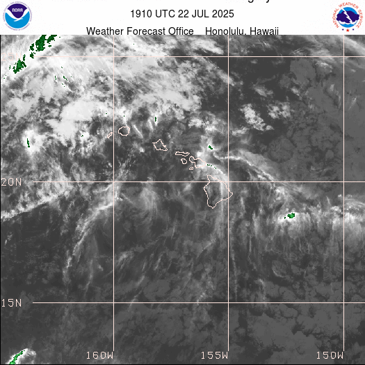
This map shows infared spectrum light for the area covering the State of Hawaii. This Satellite format is available 24 hours a day. You may need to refresh your browser to see any changes as it updated several times an hour. The time displayed on the map is UTC, NOT Hawaii Standard Time - (HST).


1 Kilometer Visible - Hawaiian Satellite Loop


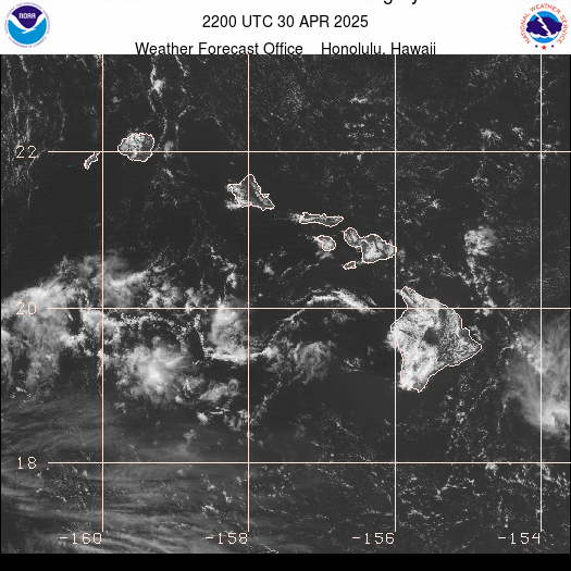
This map shows visiable cloud formations passing over the State of Hawaii. Since it is visiable light, it needs to be daylight for anything to show on this image. As a result, this map will not be updated during the nighttime hours and will only have updated information during the daylight hours. You may need to refresh your browser to see any changes The time displayed on the map is UTC, NOT Hawaiian Standard Time- (HST).


1 Km Visible Radar - Hawaii


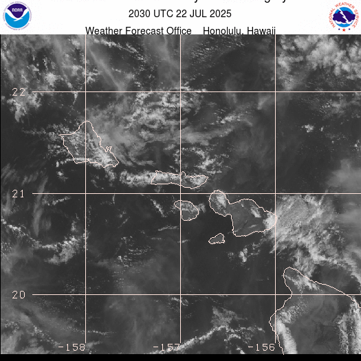
1 Kilometer Visible - Oahu/Maui Satellite Loop


This map shows visiable cloud formations passing over the Oahu and Maui Region. Since it is visiable light, it needs to be daylight for anything to show on this image. As a result, this map will not be updated during the nighttime hours and will only have updated information during the daylight hours. You may need to refresh your browser to see any changes The time displayed on the map is UTC, NOT Hawaiian Standard Time- (HST).


 1 Km Visible Radar - Oahu/Maui Hawaii


Click Here to Return to the: Current Hawaiian Weather Page

Please Visit our other Hawaiian Pages: Hawaiian Earthquake Activity Page ·  Hawaiian Tsunami Info  ·  Hawaiian Volcanos Activity Page


Kãne‘ohe and Kãne‘ohe Bay with the Koolau Mountains as backdrop - Windward - Oahu, Hawaii

Kaneohe and Kaneohe Bay - Oahu, Hi


Member of the:
LightningRing
World Weather Websites

 Pepper Ridge North Valley Random Weather Facts

RAINFALL
Terms such as "slight chance" of rain (10-20%), "chance" of rain (30-50%) or rain "likely" (60-70%) are used when there is uncertainty of receiving measurable precipitation anywhere in the forecast area (such as the Greater Phoenix Area). For instance, if there is only a 30-50 percent chance that rain will fall anywhere in the Phoenix Metro area, then the forecast will call for a "chance" of rain.

Get the Facts PHP


Page layout last updated on Mar 25th, 2024