Welcome to the Pepper Ridge North Valley's
Severe Weather Page
This is your weather warning resource page. Check this page for the latest watches and warning updates,
from The National Weather Service, Phoenix, Az.!
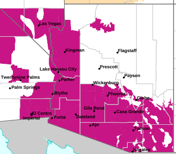
MAP OF CURRENT SOUTHWEST WATCHES, WARNINGS AND ADVISORIES
Local & Regional Weather Statements, Watches And Warnings
Weather Alerts for Gila CountyIssued by the National Weather Service |
 FLASH FLOOD WARNING FLASH FLOOD WARNING |
| GILA COUNTY |
Areas Affected:
Coconino, AZ - Gila, AZ |
| Effective: Tue, 7/21 1:33pm |
Updated: Tue, 7/21 2:03pm |
Urgency: Immediate |
| Expires: Tue, 7/21 4:30pm |
Severity: Severe |
Certainty: Likely |
|
Details:
FFWFGZ

The National Weather Service in Flagstaff has issued a

* Flash Flood Warning for...
Gila County in east central Arizona...
Coconino County in north central Arizona...

* Until 430 PM MST.

* At 133 PM MST, Doppler radar indicated thunderstorms producing
heavy rain across the warned area. Flash flooding is ongoing or
expected to begin shortly.

HAZARD...Life threatening flash flooding. Thunderstorms producing
flash flooding.

SOURCE...Radar indicated.

IMPACT...Life threatening flash flooding of creeks and streams,
normally dry washes, urban areas, highways, streets and
underpasses.

* Some locations that will experience flash flooding include...
Forest Lakes, Willow Springs Canyon Lake, Mogollon Rim Visitor
Center and Colcord Mountain Estates.

This includes State Route 260 between mile markers 282 and 285.

This includes the following recreation areas and campgrounds...
Sinkhole Campground, Forest Road 171 Camping Area, Airplane Flat
Campground, Colcord Ridge Campground, Sinkhole Campground, Forest
Road 9512E Camping Area, Upper Canyon Creek Campground and Willow
Springs Lake Recreation Area.

This includes the following creeks, washes and rivers...
Chevelon Canyon.
Information:
Flooding of washes and creeks will occur, some dirt roads will become
muddy and impassable. Paved roads and underpasses could become
flooded as well.

Be aware of your surroundings and do not drive on flooded roads. |
 FLOOD WATCH FLOOD WATCH |
| GILA COUNTY |
Areas Affected:
Tonto Basin - San Carlos - Globe/Miami - Southeast Gila County |
| Effective: Tue, 7/21 12:43pm |
Updated: Tue, 7/21 2:03pm |
Urgency: Future |
| Expires: Tue, 7/21 10:00pm |
Severity: Severe |
Certainty: Possible |
|
Details:
* WHAT...Flash flooding caused by excessive rainfall is possible.

* WHERE...A portion of south central Arizona, including the following
areas, Globe/Miami, San Carlos, Southeast Gila County and Tonto
Basin.

* WHEN...Until 10 PM MST this evening.

* IMPACTS...Excessive runoff may result in flooding of rivers,
creeks, streams, and other low-lying and flood-prone locations.

* ADDITIONAL DETAILS...
- Deep monsoon moisture in place across Eastern Arizona will lead
to storms capable of producing rainfall between 1-2 inches per
hour, to locally higher, resulting in an enhanced risk of flash
flooding.
- http://www.weather.gov/safety/flood
Information:
You should monitor later forecasts and be alert for possible Flood
Warnings. Those living in areas prone to flooding should be prepared
to take action should flooding develop. |
| FLOOD WATCH |
| GILA COUNTY |
Areas Affected:
Kaibab Plateau - Marble and Glen Canyons - Grand Canyon Country - Coconino Plateau - Yavapai County Mountains - Northeast Plateaus and Mesas Hwy 264 Northward - Little Colorado River Valley in Coconino County - Little Colorado River Valley in Navajo County - Little Colorado River Valley in Apache County - Western Mogollon Rim - Eastern Mogollon Rim - White Mountains - Northern Gila County - Yavapai County Valleys and Basins - Oak Creek and Sycamore Canyons - Black Mesa Area - Northeast Plateaus and Mesas South of Hwy 264 |
| Effective: Tue, 7/21 4:04am |
Updated: Tue, 7/21 2:03pm |
Urgency: Future |
| Expires: Tue, 7/21 10:00pm |
Severity: Severe |
Certainty: Possible |
|
Details:
* WHAT...Flash flooding caused by excessive rainfall continues to be
possible.

* WHERE...Yavapai County, Coconino County, northern Gila County,
Navajo County, central and southern Apache County.

* WHEN...From 11 AM MST  /noon MDT/ this morning through this
evening.

* IMPACTS...Flash flooding will be possible in creeks, normally dry
washes, swimming holes, and over recently burned areas. Raging
killer currents will be possible in side canyons and narrow slot
canyons. Low-water crossings may be flooded.

* ADDITIONAL DETAILS...
- Deep monsoon moisture in place across northern Arizona will lead
to storms capable of producing rainfall in excess of 2 inches per
hour, resulting in an enhanced risk of flash flooding.
- Additional information is available at weather.gov/flagstaff.
Information:
Have a way to receive Flash Flood Warnings and be prepared to take
action should warnings be issued.

Consider changing your plans if you were going to hike, boat, or
paddleboard to a slot canyon or normally dry wash. If you do still
decide to recreate, check in at a nearby visitor center or ranger
station. |
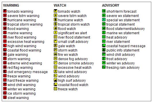
Key to Icons for Local & Regional Weather Statements, Watches And Warnings
Map of the Current Watches, Warnings, and Advisories Nationwide:

|
|
Member of the:


|
North Valley Random Weather Facts |
THERMAL LOW (Heat Low)
During the summer the intense Arizona heat causes the formation of a thermal low (heat low), this thermal low usually forms near Yuma. It is usually formed by the intense thermal updrafts and rapidly rising air that cause lower Barometric pressure levels whichs leads to the formation of a surface low pressure area. This feature can enhance the moisture levels during the monsoon by pulling in low level moisture from Baja California.
Get the Facts PHP
|
|
Page layout last updated on Mar 8th, 2024
|
|
|



 New Feature