Welcome to the Pepper Ridge North Valley's
Severe Weather Page
This is your weather warning resource page. Check this page for the latest watches and warning updates,
from The National Weather Service, Phoenix, Az.!
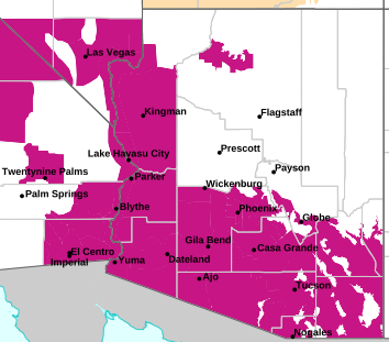
MAP OF CURRENT SOUTHWEST WATCHES, WARNINGS AND ADVISORIES
Local & Regional Weather Statements, Watches And Warnings
Weather Alerts for La Paz CountyIssued by the National Weather Service |
 EXTREME HEAT WATCH EXTREME HEAT WATCH |
| LA PAZ COUNTY |
Areas Affected:
Parker Valley - Yuma - Imperial County Southwest - Salton Sea - Chuckwalla Mountains - Imperial County Southeast - Imperial County West - Imperial Valley - Chiriaco Summit - Palo Verde Valley - Chuckwalla Valley |
| Effective: Mon, 7/20 11:54am |
Updated: Mon, 7/20 11:10pm |
Urgency: Future |
| Expires: Tue, 7/21 5:00am |
Severity: Severe |
Certainty: Likely |
|
Details:
* WHAT...Dangerously hot conditions possible. Afternoon temperatures
104 to 113. Major Heat Risk. Overexposure can cause heat cramps and
heat exhaustion to develop and, without intervention, can lead to
heat stroke.

* WHERE...Portions of southwest Arizona and southeast and southern
California.

* WHEN...From Wednesday morning through Monday evening.

* IMPACTS...Heat related illnesses increase significantly during
extreme heat events.
Information:
An Extreme Heat Watch means that a period of very hot temperatures,
even by local standards, may occur. Actions should be taken to lessen
the impact of the extreme heat.

Take extra precautions if you work or spend time outside. When
possible, reschedule strenuous activities to early morning or
evening. Know the signs and symptoms of heat exhaustion and heat
stroke. Wear lightweight and loose-fitting clothing when possible and
drink plenty of water.

To reduce risk during outdoor work, the Occupational Safety and
Health Administration recommends scheduling frequent rest breaks in
shaded or air conditioned environments. Anyone overcome by heat
should be moved to a cool and shaded location. Heat stroke is an
emergency! Call 9 1 1.

Public cooling shelters are available in some areas. Consult county
officials for more details. |
| EXTREME HEAT WATCH |
| LA PAZ COUNTY |
Areas Affected:
Kofa - Central La Paz - Southeast Yuma County - Gila River Valley - Joshua Tree NP West - Joshua Tree NP East |
| Effective: Mon, 7/20 11:54am |
Updated: Mon, 7/20 11:10pm |
Urgency: Future |
| Expires: Tue, 7/21 5:00am |
Severity: Severe |
Certainty: Likely |
|
Details:
* WHAT...Dangerously hot conditions possible. Afternoon temperatures
105 to 116. Major Heat Risk. Overexposure can cause heat cramps and
heat exhaustion to develop and, without intervention, can lead to
heat stroke.

* WHERE...In Arizona, Central La Paz, Gila River Valley, Kofa, and
Southeast Yuma County. In California, Joshua Tree NP East and
Joshua Tree NP West.

* WHEN...From Thursday morning through Monday evening.

* IMPACTS...Heat related illnesses increase significantly during
extreme heat events.
Information:
An Extreme Heat Watch means that a period of very hot temperatures,
even by local standards, may occur. Actions should be taken to lessen
the impact of the extreme heat.

Take extra precautions if you work or spend time outside. When
possible, reschedule strenuous activities to early morning or
evening. Know the signs and symptoms of heat exhaustion and heat
stroke. Wear lightweight and loose-fitting clothing when possible and
drink plenty of water.

To reduce risk during outdoor work, the Occupational Safety and
Health Administration recommends scheduling frequent rest breaks in
shaded or air conditioned environments. Anyone overcome by heat
should be moved to a cool and shaded location. Heat stroke is an
emergency! Call 9 1 1.

Public cooling shelters are available in some areas. Consult county
officials for more details. |
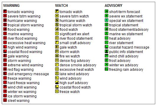
Key to Icons for Local & Regional Weather Statements, Watches And Warnings
Map of the Current Watches, Warnings, and Advisories Nationwide:

|
|
Member of the:


|
North Valley Random Weather Facts |
RAINFALL
Terms such as "slight chance" of rain (10-20%), "chance" of rain (30-50%) or rain "likely" (60-70%) are used when there is uncertainty of receiving measurable precipitation anywhere in the forecast area (such as the Greater Phoenix Area). For instance, if there is only a 30-50 percent chance that rain will fall anywhere in the Phoenix Metro area, then the forecast will call for a "chance" of rain.
Get the Facts PHP
|
|
Page layout last updated on Mar 8th, 2024
|
|
|

 New Feature