Welcome to the Pepper Ridge North Valley's
Severe Weather Page
This is your weather warning resource page. Check this page for the latest watches and warning updates,
from The National Weather Service, Phoenix, Az.!
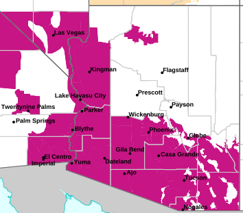
MAP OF CURRENT SOUTHWEST WATCHES, WARNINGS AND ADVISORIES
Local & Regional Weather Statements, Watches And Warnings
Weather Alerts for Pima CountyIssued by the National Weather Service |
 FLOOD ADVISORY FLOOD ADVISORY |
| PIMA COUNTY |
Areas Affected:
Pima, AZ |
| Effective: Mon, 7/20 9:39pm |
Updated: Mon, 7/20 11:10pm |
Urgency: Expected |
| Expires: Mon, 7/20 11:45pm |
Severity: Minor |
Certainty: Likely |
|
Details:
* WHAT...Urban area and small stream flooding caused by excessive
rainfall is expected.

* WHERE...Northeastern Pima County in southeastern Arizona...

* WHEN...Until 1145 PM MST.

* IMPACTS...Minor flooding in low-lying and poor drainage areas.
Overflowing poor drainage areas.

* ADDITIONAL DETAILS...
- At 939 PM MST, Doppler radar and automated rain gauges indicated
heavy rain due to thunderstorms. This  will cause urban and small
stream flooding. Between 0.5 and 1.2 inches of rain have fallen.
- This includes the following streams and drainages...
Robles Wash, Los, Oro, Caada del, Big Wash, Indian Well Wash,
Santa Cruz River, Chalk Creek, Rillito River and Guild Wash.
Additional rainfall amounts up to 0.8 inches are expected over
the area. This additional rain will result in minor flooding.
- Some locations that will experience flooding include...
Oro Valley, Marana, Casas Adobes, Tortolita and Dove Mountain.
- This includes the following highways...
Route 77 between mile markers 75 and 79. Interstate 10 between
mile markers 233 and 248.

This includes the following Flash Flood Prone Locations...
Overton Rd at Canada del Oro.
- http://www.weather.gov/safety/flood
Information:
Turn around, don't drown when encountering flooded roads. Most flood
deaths occur in vehicles.

Be especially cautious at night when it is harder to recognize the
dangers of flooding. |
 FLOOD WATCH FLOOD WATCH |
| PIMA COUNTY |
Areas Affected:
Upper Santa Cruz River and Altar Valleys including Nogales - Upper San Pedro River Valley including Sierra Vista/Benson - Eastern Cochise County Below 5000 Feet including Douglas/Willcox - Upper Gila River and Aravaipa Valleys including Clifton/Safford - White Mountains of Graham and Greenlee Counties including Hannagan Meadow - Galiuro and Pinaleno Mountains including Mount Graham - Chiricahua Mountains including Chiricahua National Monument - Dragoon/Mule/Huachuca and Santa Rita Mountains including Bisbee/Canelo Hills/Madera Canyon |
| Effective: Mon, 7/20 11:10am |
Updated: Mon, 7/20 11:10pm |
Urgency: Future |
| Expires: Tue, 7/21 3:00am |
Severity: Severe |
Certainty: Possible |
|
Details:
* WHAT...Flash flooding caused by excessive rainfall continues to be
possible.

* WHERE...Portions of Southeast Arizona including Graham, Greenlee,
Cochise and Santa Cruz counties.

* WHEN...Through Tuesday evening. The greatest risk is Monday
afternoon and evening and again Tuesday afternoon and evening.

* IMPACTS...Excessive runoff may result in flooding of rivers,
creeks, dry washes, and other low-lying and flood-prone locations.

* ADDITIONAL DETAILS...
- The combination of ample moisture across southeast Arizona and an
upper-level disturbance moving into the area from New Mexico
today will result in widespread showers and thunderstorms...
especially south and east of Tucson. These storms will be capable
of producing heavy rainfall, with localized rainfall amounts
between 1 and 3 inches. Given how saturated soils are across the
area from storms over the past week, there is an increased
potential for rainfall runoff to produce flash flooding.
- http://www.weather.gov/safety/flood
Information:
You should monitor later forecasts and be prepared to take action
should Flash Flood Warnings be issued. |
Key to Icons for Local & Regional Weather Statements, Watches And Warnings
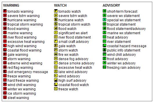
Map of the Current Watches, Warnings, and Advisories Nationwide:

|
|
Member of the:


|
North Valley Random Weather Facts |
CWOP PROGRAM
The Citizen Weather Observer Program (CWOP) is a private-public partnership with three main goals: 1) to collect weather data contributed by citizens; 2) to make these data available for weather services and homeland security; and 3) to provide feedback to the data contributors so that they have the tools to check and improve their data quality. In fact, the web address, wxqa.com, stands for weather quality assurance.
Get the Facts PHP
|
|
Page layout last updated on Mar 8th, 2024
|
|
|



 New Feature