Welcome to the Pepper Ridge North Valley's
Severe Weather Page
This is your weather warning resource page. Check this page for the latest watches and warning updates,
from The National Weather Service, Phoenix, Az.!
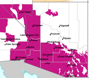
MAP OF CURRENT SOUTHWEST WATCHES, WARNINGS AND ADVISORIES
Local & Regional Weather Statements, Watches And Warnings
Weather Alerts for Coconino County/Flagstaff & Kaibab PlateauIssued by the National Weather Service |
 WIND ADVISORY WIND ADVISORY |
| COCONINO COUNTY/FLAGSTAFF & KAIBAB PLATEAU |
Areas Affected:
Kaibab Plateau - Grand Canyon Country - Coconino Plateau - Yavapai County Mountains - Western Mogollon Rim - Yavapai County Valleys and Basins - Oak Creek and Sycamore Canyons |
| Effective: Thu, 10/15 11:59am |
Updated: Thu, 10/15 7:15pm |
Urgency: Expected |
| Expires: Fri, 10/16 6:00pm |
Severity: Moderate |
Certainty: Likely |
|
Details:
* WHAT...Northeast winds 20 to 30 mph, with gusts from 45 to 55 mph.

* WHERE...Portions of Yavapai and Coconino counties, but especially
downwind of higher terrain features or near the southwestern side
of higher terrain features.

* WHEN...Until 6 PM MST Friday.

* IMPACTS...Gusty winds will blow around unsecured objects. Travel
will be difficult, especially for high profile vehicles.
Information:
Winds this strong can make driving difficult, especially for high
profile vehicles, such as RVs, campers, and tractor trailers. Use
extra caution.

Secure loose outdoor objects that could be blown around or damaged by
the wind. |
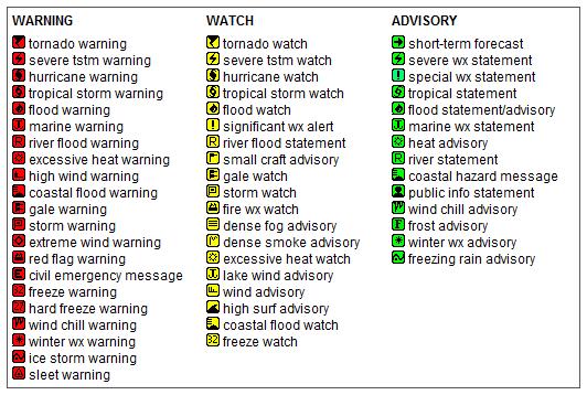
Key to Icons for Local & Regional Weather Statements, Watches And Warnings
Map of the Current Watches, Warnings, and Advisories Nationwide:

|
|
Member of the:


|
North Valley Random Weather Facts |
HUMIDEX
Definition Humidex - Over the years, several measures have been proposed to relate various combinations of temperature and humidity into a single number to approximate what hot, humid weather feels like to the average person. Of these, humidex is the one most familiar to Canadians. Humidex was introduced into Canada in 1965. The index is a summer analogue of the wind chill factor in that it is an equivalent air temperature. Air of a given temperature and humidity is equated in comfort to air of a higher temperature that has a negligible moisture content. Comfort is quite subjective and largely dependent on the age and health of the individual. Weather conditions causing prickly heat in an infant may result in heat cramps in a teenager, heat exhaustion in a middle-aged and heat stroke in a senior. Humidex is also limited as an overall hot-weather comfort index because it does not consider other factors such as pressure, wind speed, precipitation, sunshine or pollen.
Get the Facts PHP
|
|
Page layout last updated on Mar 8th, 2024
|
|
|




 New Feature