Welcome to the Pepper Ridge North Valley's
Severe Weather Page
This is your weather warning resource page. Check this page for the latest watches and warning updates,
from The National Weather Service, Phoenix, Az.!
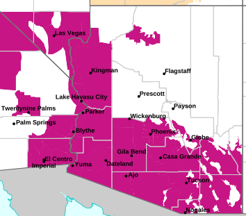
MAP OF CURRENT SOUTHWEST WATCHES, WARNINGS AND ADVISORIES
Local & Regional Weather Statements, Watches And Warnings
Weather Alerts for Grand Canyon CountryIssued by the National Weather Service |
 WIND ADVISORY WIND ADVISORY |
| GRAND CANYON COUNTRY |
Areas Affected:
Kaibab Plateau - Marble and Glen Canyons - Grand Canyon Country - Coconino Plateau - Yavapai County Mountains - Northeast Plateaus and Mesas Hwy 264 Northward - Chinle Valley - Chuska Mountains and Defiance Plateau - Little Colorado River Valley in Coconino County - Little Colorado River Valley in Navajo County - Little Colorado River Valley in Apache County - Western Mogollon Rim - Eastern Mogollon Rim - White Mountains - Northern Gila County - Yavapai County Valleys and Basins - Oak Creek and Sycamore Canyons - Black Mesa Area - Northeast Plateaus and Mesas South of Hwy 264 |
| Effective: Sat, 10/10 11:08am |
Updated: Sat, 10/10 4:55pm |
Urgency: Expected |
| Expires: Sun, 10/11 11:00am |
Severity: Moderate |
Certainty: Likely |
|
Details:
* WHAT...South winds 20 to 30 mph with gusts 45 to 55 mph expected.

* WHERE...All of central and northern Arizona.

* WHEN...From 8 AM MST /9 AM MDT/ to 8 PM MST /9 PM MDT/ Sunday.

* IMPACTS...Gusty winds will blow around unsecured objects. Tree
limbs could snap resulting in a few power outages. Travel will be
difficult, especially for high profile vehicles.
Information:
Winds this strong can make driving difficult, especially for high
profile vehicles, such as RVs, campers, and tractor trailers. Use
extra caution.

Secure loose outdoor objects that could be blown around or damaged by
the wind. |
 FLOOD WATCH FLOOD WATCH |
| GRAND CANYON COUNTRY |
Areas Affected:
Kaibab Plateau - Marble and Glen Canyons - Grand Canyon Country - Coconino Plateau - Yavapai County Mountains - Western Mogollon Rim - Eastern Mogollon Rim - Northern Gila County - Yavapai County Valleys and Basins - Oak Creek and Sycamore Canyons |
| Effective: Sat, 10/10 11:08am |
Updated: Sat, 10/10 4:55pm |
Urgency: Future |
| Expires: Sun, 10/11 5:00am |
Severity: Severe |
Certainty: Possible |
|
Details:
* WHAT...Flash flooding caused by excessive rainfall continues to be
possible.

* WHERE...western Coconino, northern Gila, far southern Navajo, and
Yavapai counties.

* WHEN...Through late Sunday night.

* IMPACTS...Flash flooding will be possible in creeks, normally dry
washes, swimming holes, and over recently burned areas. Raging
killer currents will be possible in side canyons and narrow slot
canyons. Low-water crossings may be flooded.

* ADDITIONAL DETAILS...
- Showers and thunderstorms are expected to increase in coverage
through today, and continue through the overnight hours into
Sunday. With deep tropical moisture in place from the remnants of
Tropical Storm Rachel, periods of embedded heavy rainfall will be
possible leading to flash flooding. Additionally, the extended
period of rain could lead to elevated flow in creeks, normally
dry washes, and rivers.
- Additional information is available at weather.gov/flagstaff.
Information:
Have a way to receive Flash Flood Warnings and be prepared to take
action should warnings be issued. |
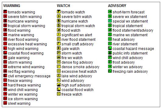
Key to Icons for Local & Regional Weather Statements, Watches And Warnings
Map of the Current Watches, Warnings, and Advisories Nationwide:

|
|
Member of the:


|
North Valley Random Weather Facts |
THERMAL LOW (Heat Low)
During the summer the intense Arizona heat causes the formation of a thermal low (heat low), this thermal low usually forms near Yuma. It is usually formed by the intense thermal updrafts and rapidly rising air that cause lower Barometric pressure levels whichs leads to the formation of a surface low pressure area. This feature can enhance the moisture levels during the monsoon by pulling in low level moisture from Baja California.
Get the Facts PHP
|
|
Page layout last updated on Mar 8th, 2024
|
|
|




 New Feature