Welcome to the Pepper Ridge North Valley's
Severe Weather Page
This is your weather warning resource page. Check this page for the latest watches and warning updates,
from The National Weather Service, Phoenix, Az.!
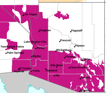
MAP OF CURRENT SOUTHWEST WATCHES, WARNINGS AND ADVISORIES
Local & Regional Weather Statements, Watches And Warnings
Weather Alerts for Eastern Cochise County & Douglas/WilcoxIssued by the National Weather Service |
 FLOOD WATCH FLOOD WATCH |
| EASTERN COCHISE COUNTY & DOUGLAS/WILCOX |
Areas Affected:
Upper Santa Cruz River and Altar Valleys including Nogales - Upper San Pedro River Valley including Sierra Vista/Benson - Eastern Cochise County Below 5000 Feet including Douglas/Willcox - Upper Gila River and Aravaipa Valleys including Clifton/Safford - White Mountains of Graham and Greenlee Counties including Hannagan Meadow - Galiuro and Pinaleno Mountains including Mount Graham - Chiricahua Mountains including Chiricahua National Monument - Dragoon/Mule/Huachuca and Santa Rita Mountains including Bisbee/Canelo Hills/Madera Canyon |
| Effective: Mon, 7/20 11:10am |
Updated: Mon, 7/20 11:10pm |
Urgency: Future |
| Expires: Tue, 7/21 3:00am |
Severity: Severe |
Certainty: Possible |
|
Details:
* WHAT...Flash flooding caused by excessive rainfall continues to be
possible.

* WHERE...Portions of Southeast Arizona including Graham, Greenlee,
Cochise and Santa Cruz counties.

* WHEN...Through Tuesday evening. The greatest risk is Monday
afternoon and evening and again Tuesday afternoon and evening.

* IMPACTS...Excessive runoff may result in flooding of rivers,
creeks, dry washes, and other low-lying and flood-prone locations.

* ADDITIONAL DETAILS...
- The combination of ample moisture across southeast Arizona and an
upper-level disturbance moving into the area from New Mexico
today will result in widespread showers and thunderstorms...
especially south and east of Tucson. These storms will be capable
of producing heavy rainfall, with localized rainfall amounts
between 1 and 3 inches. Given how saturated soils are across the
area from storms over the past week, there is an increased
potential for rainfall runoff to produce flash flooding.
- http://www.weather.gov/safety/flood
Information:
You should monitor later forecasts and be prepared to take action
should Flash Flood Warnings be issued. |
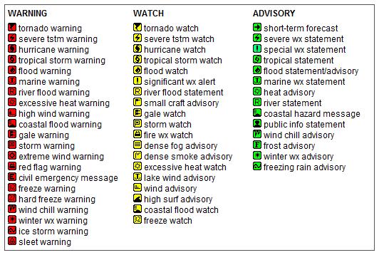
Key to Icons for Local & Regional Weather Statements, Watches And Warnings
Map of the Current Watches, Warnings, and Advisories Nationwide:

|
|
Member of the:


|
North Valley Random Weather Facts |
HABOOB
The name comes from the Arabic word habb, meaning "wind." A Haboob is a giant wall of dust sometimes 3000ft tall,that travels a 40mph+, they frequently form here in Arizona from the gust front outflow boundary of summer thunderstorms. Haboobs are most frequent in Southwestern North America during the months of May through September, with the most frequent occurrence in late June, but they can occur in every month. (A picture of a classic Haboob appears on our Monsoon Page.)
Get the Facts PHP
|
|
Page layout last updated on Mar 8th, 2024
|
|
|

 New Feature